IMAGES TAKEN NEAR TO
Baslow Avenue, MANCHESTER, M19 3GG
Introduction
This page details the photographs taken nearby to Baslow Avenue, M19 3GG by members of the Geograph project.
The Geograph project started in 2005 with the aim of publishing, organising and preserving representative images for every square kilometre of Great Britain, Ireland and the Isle of Man.

There are currently over 7.5m images from over14,400 individuals and you can help contribute to the project by visiting https://www.geograph.org.uk
Image Map
Images are licensed for reuse under creativecommons.org/licenses/by-sa/2.0
Notes
- Clicking on the map will re-center to the selected point.
- The higher the marker number, the further away the image location is from the centre of the postcode.
Image Listing (14 Images Found)
Images are licensed for reuse under creativecommons.org/licenses/by-sa/2.0
Image
Details
Distance
1
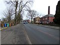
Mount Road
The B6178 from South Levenshulme to Belle Vue. The #201 bus in the background is on a long diversionary route due to closure of the A57 for bridge removal work.
Image: © Gerald England
Taken: 7 Mar 2020
0.16 miles
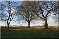
2
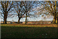
Green Bank Playing Field
A recreation ground in Levenshulme.
Image: © Bill Boaden
Taken: 10 Jan 2020
0.19 miles
3
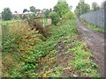
Nico Ditch
Looking west along Nico Ditch near Levenshulme, Manchester. The public footpath seen here runs between the ditch on the left and Mellands Playing Field which lies beyond the fence on the right. About 200-300 metres of the ditch survive here and little elsewhere. This ditch is believed to have been a defensive earthwork dug in a single night as protection against the Danish invasion of 869-870 AD. It varied in width and depth, but averaged between 2 and 2.5 metres deep, and extended for over five miles in length between marshes in Fallowfield and Audenshaw. SJ88249487.
Image: © Keith Williamson
Taken: 12 Oct 2005
0.20 miles
4
Green Bank Playing Field
A large recreation ground in Levenshulme viewed from Barlow Road, which is slightly below the level of the field.
Image: © Bill Boaden
Taken: 10 Jan 2020
0.20 miles
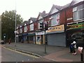
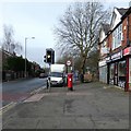
7
Shops on Barlow Road
A parade of eight shops.
Image: © Gerald England
Taken: 7 Mar 2020
0.22 miles
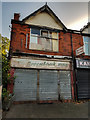
8
Barlow Road
The GR postbox (M19 566D) Image is outside what used to be a Post Office until 2008. That shop in a row of eight Image is now a barbers.
Image: © Gerald England
Taken: 7 Mar 2020
0.22 miles
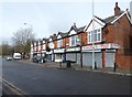
9
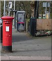
GR postbox (M19 566D)
On Barlow Road Image outside what used to be a Post Office until 2008. Behind the phone box and bus stop is an entrance to Greenbank playing fields.
Image: © Gerald England
Taken: 7 Mar 2020
0.22 miles