IMAGES TAKEN NEAR TO
Burnage Lane, MANCHESTER, M19 2WN
Introduction
This page details the photographs taken nearby to Burnage Lane, M19 2WN by members of the Geograph project.
The Geograph project started in 2005 with the aim of publishing, organising and preserving representative images for every square kilometre of Great Britain, Ireland and the Isle of Man.

There are currently over 7.5m images from over14,400 individuals and you can help contribute to the project by visiting https://www.geograph.org.uk
Image Map
Images are licensed for reuse under creativecommons.org/licenses/by-sa/2.0
Notes
- Clicking on the map will re-center to the selected point.
- The higher the marker number, the further away the image location is from the centre of the postcode.
Image Listing (7 Images Found)
Images are licensed for reuse under creativecommons.org/licenses/by-sa/2.0
Image
Details
Distance
1
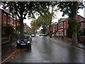
Burnage on a wet afternoon.
Looking west along Grangethorpe Drive, Burnage, Manchester Typical street for this square. SJ86749327
Image: © Keith Williamson
Taken: 12 Oct 2005
0.07 miles
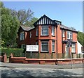
2
Burnage United Reformed Church
A 1990s replacement for a Victorian building (note the original gateposts).
Image: © John H Darch
Taken: 8 Sep 2010
0.08 miles
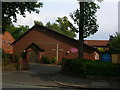
3
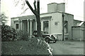
The Duchess of York Hospital for Babies, Burnage.
This hospital was popularly known as Burnage Babies. It is now, sadly, closed and the building is occupied by a nursing home for the elderly. It had a high reputation and took resident medical students as part of their paediatric teaching.
Image: © Peter Ward
Taken: Unknown
0.16 miles
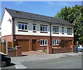
4
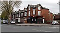
Slade Lane
Properties at the corner of Slade Lane and Milwain Street.
Image: © Peter McDermott
Taken: 17 Apr 2017
0.21 miles