IMAGES TAKEN NEAR TO
Hillcrest Drive, MANCHESTER, M19 2RX
Introduction
This page details the photographs taken nearby to Hillcrest Drive, M19 2RX by members of the Geograph project.
The Geograph project started in 2005 with the aim of publishing, organising and preserving representative images for every square kilometre of Great Britain, Ireland and the Isle of Man.

There are currently over 7.5m images from over14,400 individuals and you can help contribute to the project by visiting https://www.geograph.org.uk
Image Map
Images are licensed for reuse under creativecommons.org/licenses/by-sa/2.0
Notes
- Clicking on the map will re-center to the selected point.
- The higher the marker number, the further away the image location is from the centre of the postcode.
Image Listing (37 Images Found)
Images are licensed for reuse under creativecommons.org/licenses/by-sa/2.0
Image
Details
Distance
1
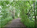
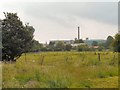
Highfield Country Park
Footpath near Cringle Road. Highfield Country Park is a 70 acre area of open land that stretches to the east of Broom Avenue across to the back of Houldsworth Golf Course and over to the junction of Longford Road and Nelstrop Road.
Image: © Gerald England
Taken: 27 Jun 2009
0.09 miles
3
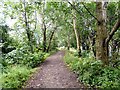
Highfield Country Park
Footpath near Cringle Road. Highfield Country Park is a 70 acre area of open land that stretches to the east of Broom Avenue across to the back of Houldsworth Golf Course and over to the junction of Longford Road and Nelstrop Road.
Image: © Gerald England
Taken: 27 Jun 2009
0.12 miles
4

Wellington Road North
Derelict buildings on Wellington Road North.
Image: © Peter McDermott
Taken: 24 Jun 2014
0.13 miles
5
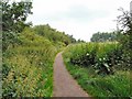
Highfield Country Park
Footpath near Cringle Road. Highfield Country Park is a 70 acre area of open land that stretches to the east of Broom Avenue across to the back of Houldsworth Golf Course and over to the junction of Longford Road and Nelstrop Road.
Image: © Gerald England
Taken: 27 Jun 2009
0.13 miles
6
Highfield Country Park
From Cringle Road looking towards Reddish. Highfield Country Park is a 70 acre area of open land that stretches to the east of Broom Avenue across to the back of Houldsworth Golf Course and over to the junction of Longford Road and Nelstrop Road.
Image: © Gerald England
Taken: 27 Jun 2009
0.13 miles
7
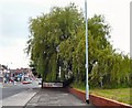
Willow Tree on Wellington Road North
The willow tree on Wellington Road North hides the KFC and petrol station behind it.
Image: © Gerald England
Taken: 27 Jun 2009
0.14 miles
8

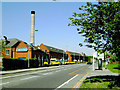
Wellington Road North
The A6 out of Manchester (Levenshulme) into Stockport (Heaton Chapel).
Image: © Gerald England
Taken: 8 Jun 2013
0.16 miles
9
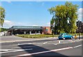
McVitie's Biscuit Factory, Wellington Road North, Stockport
The far north of Stockport, close to the border with Manchester. Looking north towards the Manchester suburb of Levenshulme.
Image: © Slbs
Taken: Unknown
0.16 miles
10
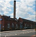
McVities Factory
On the A6 at Heaton Chapel.
Image: © Gerald England
Taken: 8 Jun 2013
0.16 miles