IMAGES TAKEN NEAR TO
Corringham Road, MANCHESTER, M19 2RG
Introduction
This page details the photographs taken nearby to Corringham Road, M19 2RG by members of the Geograph project.
The Geograph project started in 2005 with the aim of publishing, organising and preserving representative images for every square kilometre of Great Britain, Ireland and the Isle of Man.

There are currently over 7.5m images from over14,400 individuals and you can help contribute to the project by visiting https://www.geograph.org.uk
Image Map
Images are licensed for reuse under creativecommons.org/licenses/by-sa/2.0
Notes
- Clicking on the map will re-center to the selected point.
- The higher the marker number, the further away the image location is from the centre of the postcode.
Image Listing (27 Images Found)
Images are licensed for reuse under creativecommons.org/licenses/by-sa/2.0
Image
Details
Distance
1
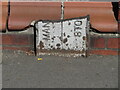
Old Boundary Marker on the A6 Wellington Road North in Stockport
Municipal Boundary Marker against the low perimeter of KFC Heaton Chapel on the east side of the A6 Wellington Road North, just south of the junction with Lloyd Road. In raised lettering MAN(chester) │ STO(ockport) both vertical and broken off.
Milestone Society National ID: CH_STOMAN01pb
Image: © Roadside Relics
Taken: 29 Apr 2019
0.12 miles
3
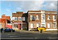
Betty Boops Snack Bar
The snack bar Image on Stockport Road Image appears to have been closed for some time. Along with two adjacent properties it is being advertised as "To Let".
Image: © Gerald England
Taken: 4 Nov 2017
0.15 miles
4
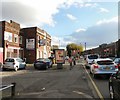
Stockport Road, Levenshulme
The A6 out of Manchester. At the traffic lights the road becomes Wellington Road North, Stockport. A sign points to Betty Boops Snack Bar Image but alas it has been closed for some time. On the Stockport side is McVitie's biscuit factory and opposite is a McDonald's.
Image: © Gerald England
Taken: 4 Nov 2017
0.15 miles
5
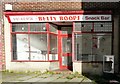
Betty Boops Snack Bar
The snack bar appears to have been closed for some time. Along with two adjacent properties Image it is being advertised as "To Let".
Image: © Gerald England
Taken: 4 Nov 2017
0.15 miles
6
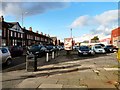
Stockport Road, Levenshulme
The A6 out of Manchester. Behind the camera the road becomes Wellington Road North, Stockport. A sign points to Betty Boops Snack Bar Image but alas it has been closed for some time.
Image: © Gerald England
Taken: 4 Nov 2017
0.15 miles
7
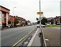
Stockport Road, Levenshulme
The A6 towards Manchester in South Levenshulme.
Image: © Gerald England
Taken: 27 Jun 2009
0.16 miles
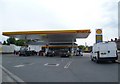
8
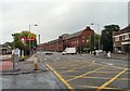
McDonald's and McVitie's
At the Manchester (Levenshulme) / Stockport (Heaton Moor) boundary, the A6 changes from being Stockport Road to Wellington Road North. On the left is a McDonald's and also a KFC. On the right is McVitie's biscuit factory.
Image: © Gerald England
Taken: 27 Jun 2009
0.16 miles
9

Wellington Road North
Derelict buildings on Wellington Road North.
Image: © Peter McDermott
Taken: 24 Jun 2014
0.16 miles
10
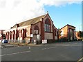
Former St Andrew's Church
The Church of St Andrew at the corner of Hardicker Street and Stockport Road (A6) was founded in 1899 although the current building which is Grade II listed https://historicengland.org.uk/listing/the-list/list-entry/1270665 dates from 1907 Image It closed as a church in 1988 and has been converted into apartments. The congregation merged with St Peter's Image
Image: © Gerald England
Taken: 4 Nov 2017
0.17 miles