IMAGES TAKEN NEAR TO
Slade Mount, Slade Lane, MANCHESTER, M19 2HB
Introduction
This page details the photographs taken nearby to Slade Mount, Slade Lane, M19 2HB by members of the Geograph project.
The Geograph project started in 2005 with the aim of publishing, organising and preserving representative images for every square kilometre of Great Britain, Ireland and the Isle of Man.

There are currently over 7.5m images from over14,400 individuals and you can help contribute to the project by visiting https://www.geograph.org.uk
Image Map
Images are licensed for reuse under creativecommons.org/licenses/by-sa/2.0
Notes
- Clicking on the map will re-center to the selected point.
- The higher the marker number, the further away the image location is from the centre of the postcode.
Image Listing (22 Images Found)
Images are licensed for reuse under creativecommons.org/licenses/by-sa/2.0
Image
Details
Distance
1
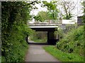
Slade Lane Bridge
A road bridge over the "Fallowfield Loop", an off-road cycleway and footpath in Manchester. The Loop is part of National Route 6 of the National Cycle Network and was previously part of the old ‘Manchester Central Station Railway’, built in the 1890s and closed in 1988.
Image: © Graham Hogg
Taken: 9 May 2012
0.04 miles
3
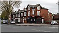
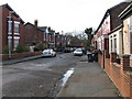
Slade Lane
Properties at the corner of Slade Lane and Milwain Street.
Image: © Peter McDermott
Taken: 17 Apr 2017
0.08 miles
4
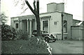
The Duchess of York Hospital for Babies, Burnage.
This hospital was popularly known as Burnage Babies. It is now, sadly, closed and the building is occupied by a nursing home for the elderly. It had a high reputation and took resident medical students as part of their paediatric teaching.
Image: © Peter Ward
Taken: Unknown
0.13 miles
5
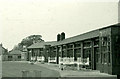
The Duchess of York Hospital for Babies
Patients' cots on the verandah
Image: © Peter Ward
Taken: Unknown
0.16 miles
6
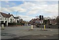
Albert Road
The B5093 at its junction with Slade Lane.
Image: © Gerald England
Taken: 5 Apr 2019
0.16 miles
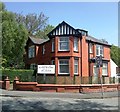
7
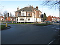
Kingsway Public House
At the northern end of the eponymous road, one of several similar dual carriageways constructed by Manchester City Council in the 1920s and 1930s to speed the city's expansion to what were then green field sites.
Image: © Peter Whatley
Taken: 21 Jan 2009
0.18 miles
9
Preston Road, Levenshulme
Typical street in this somewhat down-at-heel area.
Image: © Peter Whatley
Taken: 21 Jan 2009
0.18 miles
10
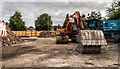
Kingsway Hotel
The car park of the demolished Kingsway Hotel public house.
Image: © Peter McDermott
Taken: 2 Jul 2019
0.19 miles