IMAGES TAKEN NEAR TO
Woodland Road, MANCHESTER, M19 2GW
Introduction
This page details the photographs taken nearby to Woodland Road, M19 2GW by members of the Geograph project.
The Geograph project started in 2005 with the aim of publishing, organising and preserving representative images for every square kilometre of Great Britain, Ireland and the Isle of Man.

There are currently over 7.5m images from over14,400 individuals and you can help contribute to the project by visiting https://www.geograph.org.uk
Image Map
Images are licensed for reuse under creativecommons.org/licenses/by-sa/2.0
Notes
- Clicking on the map will re-center to the selected point.
- The higher the marker number, the further away the image location is from the centre of the postcode.
Image Listing (43 Images Found)
Images are licensed for reuse under creativecommons.org/licenses/by-sa/2.0
Image
Details
Distance
2
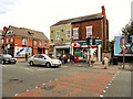
South Levenshulme Post Office
The South Levenshulme Post Office, 1082 Stockport Road.
Image: © David Dixon
Taken: 19 Aug 2011
0.13 miles
4
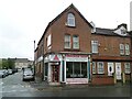
Snooker Shop
On the corner of Stockport Road and Darnforth Grove.
Image: © Gerald England
Taken: 19 Aug 2021
0.14 miles
5
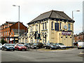
Golden Prague/Club Morova
This pub, situated on the corner of Broom Lane and Stockport Road, in Levenshulme, used to be the Wheatsheaf, which closed in 2007. In 2009, it re-opened as "The Golden Prague/Club Morova" a Czech restaurant/pub.
http://www.levyboy.com/around_town.htm has several photos from a similar viewpoint to the one above, taken at various times from the early 1900s onwards.
Image: © David Dixon
Taken: 19 Aug 2011
0.15 miles
6
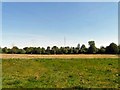
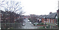
Cringle Fields Park
Cringle Fields Park is an open space which lies on the municipal boundary between the City of Manchester and the Metropolitan Borough of Stockport. The field is used for football practice, jogging and by local residents for walking their dog. It is a frequent venue for Gaelic Football Games, periodic funfairs and firework displays.
Image: © Gerald England
Taken: 4 Jun 2013
0.16 miles
7
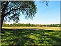
Cringle Fields Park
Cringle Fields Park is an open space which lies on the municipal boundary between the City of Manchester and the Metropolitan Borough of Stockport. The field is used for football practice, jogging and by local residents for walking their dog. It is a frequent venue for Gaelic Football Games, periodic funfairs and firework displays.
Image: © Gerald England
Taken: 4 Jun 2013
0.16 miles
8
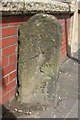
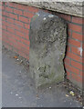
Old Milestone by the A6, Stockport Road, Levenshulme
Carved stone post by the A6, in parish of MANCHESTER (MANCHESTER District), Stockport Road, Levenshulme; opposite junction with Cringle Road, by No. 1156, on pavement against wall, on West side of road. Erected by the Manchester & Buxton turnpike trust in the 19th century.
Inscription reads:-
: To / (Manches)ter / (4) : : (To) / (Stockport) / (2) :
Milestone Society National ID: LA_LM181.
Image: © M Faherty
Taken: 17 Jul 2007
0.17 miles
9
Old Milestone by the A6, Stockport Road, Levenshulme
Carved stone post by the A6, in parish of MANCHESTER (MANCHESTER District), Stockport Road, Levenshulme; opposite junction with Cringle Road, by No. 1156, on pavement against wall, on West side of road. Erected by the Manchester & Buxton turnpike trust in the 19th century.
Inscription reads:-
: To / (Manches)ter / (4) : : (To) / (Stockport) / (2) :
Milestone Society National ID: LA_LM181.
Image: © Roadside Relics
Taken: 29 Apr 2019
0.17 miles
10
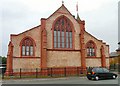
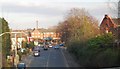
St Andrew's, Levenshulme
At the corner of Stockport Road and Hardicker Street, St Andrew's church has been converted into apartments.
Image: © Gerald England
Taken: 27 Jun 2009
0.18 miles