IMAGES TAKEN NEAR TO
Forest Range, MANCHESTER, M19 2ES
Introduction
This page details the photographs taken nearby to Forest Range, M19 2ES by members of the Geograph project.
The Geograph project started in 2005 with the aim of publishing, organising and preserving representative images for every square kilometre of Great Britain, Ireland and the Isle of Man.

There are currently over 7.5m images from over14,400 individuals and you can help contribute to the project by visiting https://www.geograph.org.uk
Image Map
Images are licensed for reuse under creativecommons.org/licenses/by-sa/2.0
Notes
- Clicking on the map will re-center to the selected point.
- The higher the marker number, the further away the image location is from the centre of the postcode.
Image Listing (115 Images Found)
Images are licensed for reuse under creativecommons.org/licenses/by-sa/2.0
Image
Details
Distance
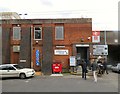
1
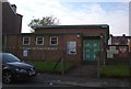
Cromwell Hall Christian Fellowship
The Assembly of God church first started around 1913 in a rented room over a shop on the corner of Stockport Road and Cromwell Grove. In 1958 the owners of the shop, then Estelle Modes selling prestigious gowns and dresses for ladies, wanted the room for their expanding business. The assembly were forced to move into temporary accommodation, initially in the Wesleyan Mission which had closed down, situated on the corner of Chapel Street and Rostron Street. They soon moved, hiring a room in the Town Hall. Midweek prayer meetings were held at the Baptist Church, Essex Street; the road later being renamed as Elmsworth Avenue. Land was bought on Marshall Road and the new church opened in 1959. http://www.cromwellhall.co.uk/home.html
Image: © Gerald England
Taken: 31 Oct 2019
0.05 miles
2
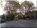
Errwood Road
From the corner of Marshall Road and Alma Road.
Image: © Gerald England
Taken: 31 Oct 2019
0.08 miles
3
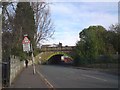
Alma Road Bridge
The bridge carries the main Manchester to Stockport railway line over Alma Road. The arch bridge has a height of 11' 3".
Image: © Gerald England
Taken: 31 Oct 2019
0.09 miles
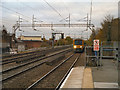
4
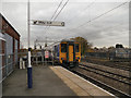
Levenshulme Station
A Class 156 Super Sprinter DMU (diesel multiple unit) departs Levenshulme Station, heading south on the Northern Rail service towards Stockport and Hazel Grove.
Image: © David Dixon
Taken: 7 Nov 2012
0.09 miles
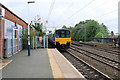
5
Levenshulme Station
A northbound class 323 electric multiple unit (EMU) approaches Levenshulme on the Northern Rail service to Manchester Piccadilly.
Image: © David Dixon
Taken: 7 Nov 2012
0.09 miles
6
Not stopping at Levenshulme
The train now passing platform two does not stop at this station.
Image: © Gerald England
Taken: 2 Jan 2018
0.09 miles
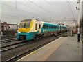
7
Sprinter at Levenshulme
Northern Rail Sprinter class DMU 150133 leaving Levenshulme station on a service from Manchester Piccadilly to Buxton.
Image: © David Dixon
Taken: 13 Aug 2018
0.09 miles
8
Levenshulme Station
The entrance to Levenshulme Station is on The Street With No Name.
Image: © Gerald England
Taken: 29 Apr 2017
0.09 miles
9

Looking south, Levenshulme railway station
The four tracks go over the B5093 Albert Road bridge, at the southern end of the platform.
Image: © El Pollock
Taken: 30 May 2014
0.10 miles
10
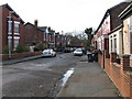
Preston Road, Levenshulme
Typical street in this somewhat down-at-heel area.
Image: © Peter Whatley
Taken: 21 Jan 2009
0.10 miles