IMAGES TAKEN NEAR TO
Peaceville Road, MANCHESTER, M19 2DQ
Introduction
This page details the photographs taken nearby to Peaceville Road, M19 2DQ by members of the Geograph project.
The Geograph project started in 2005 with the aim of publishing, organising and preserving representative images for every square kilometre of Great Britain, Ireland and the Isle of Man.

There are currently over 7.5m images from over14,400 individuals and you can help contribute to the project by visiting https://www.geograph.org.uk
Image Map
Images are licensed for reuse under creativecommons.org/licenses/by-sa/2.0
Notes
- Clicking on the map will re-center to the selected point.
- The higher the marker number, the further away the image location is from the centre of the postcode.
Image Listing (25 Images Found)
Images are licensed for reuse under creativecommons.org/licenses/by-sa/2.0
Image
Details
Distance
1
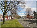
Kingsway, Fallowfield
The A5079 connects the A34 with the A6.
Image: © Gerald England
Taken: 5 Apr 2019
0.04 miles
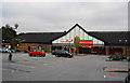
2
Sainsbury's, Rusholme
Built on the site of Birchfields Road bus depot.
Image: © Peter Whatley
Taken: 21 Jan 2009
0.05 miles
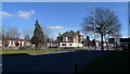
3
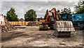
Kingsway Hotel
The car park of the demolished Kingsway Hotel public house.
Image: © Peter McDermott
Taken: 2 Jul 2019
0.06 miles
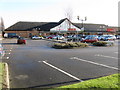
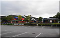
4
Two food stores
Both in Fallowfield Retail Park.
Image: © Bill Boaden
Taken: 30 Jul 2010
0.06 miles
5
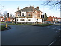
Kingsway Public House
At the northern end of the eponymous road, one of several similar dual carriageways constructed by Manchester City Council in the 1920s and 1930s to speed the city's expansion to what were then green field sites.
Image: © Peter Whatley
Taken: 21 Jan 2009
0.07 miles
6
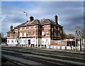
Former Kingsway Public House
The Kingsway Image on the corner of the B5093 and A5079 was once a Berni Inn and a Greenalls pub. It was acquired by Holts in the 1990s. It ceased trading in 2018 and sold to a developer with plans to either convert it to flats or to demolish it and build flats on the site.
Image: © Gerald England
Taken: 5 Apr 2019
0.07 miles
8
Road junction near the Kingsway Hotel
Moseley Road right, coming up from Levenshulme to the roundabout on Kingsway.
Image: © Geoff Royle
Taken: 4 Mar 2010
0.08 miles
9

Grocery stores off Birchfields Road
Image: © Darrin Antrobus
Taken: 25 Jun 2014
0.08 miles
10
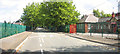
Lytham Road and Birchfields Primary School
Lytham Road looking East from Birchfields Road end with Birchfields Primary School on the right and MUTECH playing fields and pavilion on the left
Image: © Daniel P Short
Taken: 20 Aug 2005
0.09 miles