IMAGES TAKEN NEAR TO
Burnage Lane, MANCHESTER, M19 1RQ
Introduction
This page details the photographs taken nearby to Burnage Lane, M19 1RQ by members of the Geograph project.
The Geograph project started in 2005 with the aim of publishing, organising and preserving representative images for every square kilometre of Great Britain, Ireland and the Isle of Man.

There are currently over 7.5m images from over14,400 individuals and you can help contribute to the project by visiting https://www.geograph.org.uk
Image Map
Images are licensed for reuse under creativecommons.org/licenses/by-sa/2.0
Notes
- Clicking on the map will re-center to the selected point.
- The higher the marker number, the further away the image location is from the centre of the postcode.
Image Listing (75 Images Found)
Images are licensed for reuse under creativecommons.org/licenses/by-sa/2.0
Image
Details
Distance
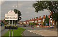
1
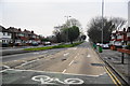
Kingsway, Burnage
The A34 seen before the morning rush-hour.
Image: © Bill Boaden
Taken: 13 Apr 2012
0.11 miles
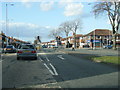
4
Kingsway, East Didsbury
The A34 into Manchester is here a wide dual carriageway with flowerbeds in the middle.
Image: © Gerald England
Taken: 12 Apr 2009
0.13 miles
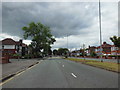
5
A34 Kingsway, Burnage
The southbound carriageway carries traffic away from Manchester.
Image: © Geoff Royle
Taken: 11 Aug 2009
0.15 miles
6
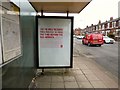
You're only reading this poster to pass the time before the bus arrives
It is actually a message from the British Heart Foundations and the smaller print reads:
"It doesn't really matter what it says, anything will do. Just something to fill the next few minutes as you stand there waiting, wondering how long before you get to where you're going. That is, if you even make it there at all. Because heart disease can kill when you least expect it. Like now. Right here at this bus stop. Before the journey ever starts. Before there's even time to reach the end of this poster. But while you're reading this, research is happening. And with research there is hope. Join the fight at bhf.org.uk and help us fight for every heartbeat. Now, what are the chances two buses turn up."
The bus stop is on the A5145 at East Didsbury and you could easily miss a couple of buses while reading this poster.
Image: © Gerald England
Taken: 18 Feb 2017
0.15 miles
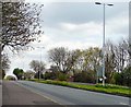
7
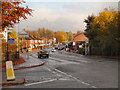
A5145 (Parrs Wood Lane/Didsbury)
Entering Stockport from East Didsbury, the A5145 changes name from Parrs Wood Lane to Didsbury Road.
Image: © David Dixon
Taken: 29 Oct 2012
0.16 miles
8
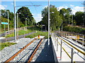
East Didsbury: Looking eastwards to the future
Looking east from the end of the Metrolink tracks at East Didsbury, the unused tunnel shows the way to Stockport, only three miles away. It can only be a matter of time before the good citizens of Stockport are asking for the extension.
Image: © Dr Neil Clifton
Taken: 22 Sep 2013
0.16 miles
9
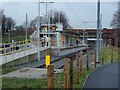
Tram terminus, East Didsbury
The start of the tracks and the station at the terminus of the tram line from the centre of Manchester. The route runs through to Oldham and Rochdale, but the line was closed for work beyond the city centre for a week in January 2014, hence the destination of Central Park being displayed.
Image: © Andrew Hill
Taken: 22 Jan 2014
0.16 miles
10
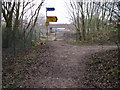
Footpath at site of East Didsbury Metrolink Station
Image: © Chris Wimbush
Taken: 20 Jan 2011
0.16 miles