IMAGES TAKEN NEAR TO
Hurstfold Avenue, MANCHESTER, M19 1RE
Introduction
This page details the photographs taken nearby to Hurstfold Avenue, M19 1RE by members of the Geograph project.
The Geograph project started in 2005 with the aim of publishing, organising and preserving representative images for every square kilometre of Great Britain, Ireland and the Isle of Man.

There are currently over 7.5m images from over14,400 individuals and you can help contribute to the project by visiting https://www.geograph.org.uk
Image Map
Images are licensed for reuse under creativecommons.org/licenses/by-sa/2.0
Notes
- Clicking on the map will re-center to the selected point.
- The higher the marker number, the further away the image location is from the centre of the postcode.
Image Listing (10 Images Found)
Images are licensed for reuse under creativecommons.org/licenses/by-sa/2.0
Image
Details
Distance
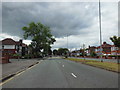
1
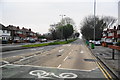
A34 Kingsway, Burnage
The southbound carriageway carries traffic away from Manchester.
Image: © Geoff Royle
Taken: 11 Aug 2009
0.05 miles
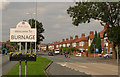
4
Kingsway, Burnage
The A34 seen before the morning rush-hour.
Image: © Bill Boaden
Taken: 13 Apr 2012
0.12 miles
5
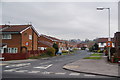
Kentstone Avenue, Burnage
A newer housing development in a large area of residential suburbia.
Image: © Bill Boaden
Taken: 13 Apr 2012
0.14 miles
6
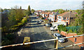
School Lane
Viewed from a train heading to Blackpool North.
Image: © Thomas Nugent
Taken: 19 Oct 2018
0.18 miles
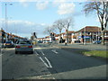
7
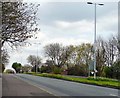
Kingsway, East Didsbury
The A34 into Manchester is here a wide dual carriageway with flowerbeds in the middle.
Image: © Gerald England
Taken: 12 Apr 2009
0.20 miles
8
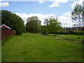
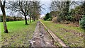
The green divide
An area of green off Burnage lane marks the divide between Stockport and Manchester.
Image: © Anthony Vosper
Taken: 2 Jun 2015
0.22 miles
9
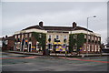
The Parrswood, Didsbury
Massive pub building which is still operating.
Image: © Bill Boaden
Taken: 13 Apr 2012
0.24 miles