IMAGES TAKEN NEAR TO
Errwood Road, MANCHESTER, M19 1JB
Introduction
This page details the photographs taken nearby to Errwood Road, M19 1JB by members of the Geograph project.
The Geograph project started in 2005 with the aim of publishing, organising and preserving representative images for every square kilometre of Great Britain, Ireland and the Isle of Man.

There are currently over 7.5m images from over14,400 individuals and you can help contribute to the project by visiting https://www.geograph.org.uk
Image Map
Images are licensed for reuse under creativecommons.org/licenses/by-sa/2.0
Notes
- Clicking on the map will re-center to the selected point.
- The higher the marker number, the further away the image location is from the centre of the postcode.
Image Listing (15 Images Found)
Images are licensed for reuse under creativecommons.org/licenses/by-sa/2.0
Image
Details
Distance
1
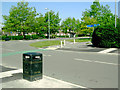
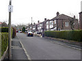
Junction of Errwood Road & Shawbrook Road, Manchester
Taken from the east side of Errwood Road, which is the slightly more distant of the two roads in the photograph.
Note that some wag has turned the blue direction signs through 90 degrees so that instead of pointing north and south along Errwood Road they now direct walkers and cyclists east and west along Shawbrook Road.
Image: © Slbs
Taken: Unknown
0.07 miles
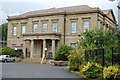
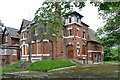
3
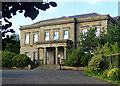
Mauldeth Hall, Heaton Moor
A Greek Revival villa with a Doric portico built "between 1832 and 1840 for Joseph Chessborough Dyer, an inventor who came to Manchester in 1812". It employed "recently developed fire-resistant building techniques for a dwelling, using Hodgkinson cast-iron beams [which had been developed in Manchester]". Grade II listed.
It was a hospital for many years, but according to Wikipedia is now the official residence of the Chinese Consul General. Enabling development seems to have mushroomed behind.
Image: © Stephen Richards
Taken: 17 Aug 2016
0.15 miles
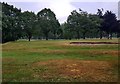
5
Pearn Road, Burnage
A view from the entrance to Pearn Road, Burnage, a small cul-de-sac named after local notary 'Lord Pearn', who was instrumental in the building of the Manchester Ship Canal. He lived in 'Burnage House' which existed on this site in antiquity.
Image: © Matthew Wilkinson
Taken: 17 Mar 2004
0.18 miles
7
Santaidd, Burnage Lane, Manchester
A "wonderfully monstrous" Victorian villa (1887) representing the increasing influence of Manchester on the village of Burnage.
It has since been restored and converted into an unfeasibly large number of flats (probably).
Image: © Stephen Richards
Taken: 27 May 2016
0.21 miles
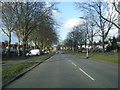
8
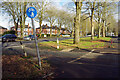
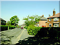
Errwood Road, Burnage
Errwood Road was built in the years after the First World War as part of Manchester Corporation's huge housing development in the Burnage area. The broad avenue, with its mature trees, has a pleasant appearance, even today.
Image: © Stephen McKay
Taken: 30 Dec 2024
0.21 miles
9
Fair Oak Road, Manchester
Looking west from the north side of the road close to its junction with Errwood Road.
Image: © Slbs
Taken: Unknown
0.21 miles
10
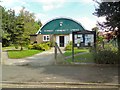
Burnage Community Centre
On Burnage Lane.
Image: © Gerald England
Taken: 24 Aug 2016
0.22 miles