IMAGES TAKEN NEAR TO
Broadlea Road, MANCHESTER, M19 1BG
Introduction
This page details the photographs taken nearby to Broadlea Road, M19 1BG by members of the Geograph project.
The Geograph project started in 2005 with the aim of publishing, organising and preserving representative images for every square kilometre of Great Britain, Ireland and the Isle of Man.

There are currently over 7.5m images from over14,400 individuals and you can help contribute to the project by visiting https://www.geograph.org.uk
Image Map
Images are licensed for reuse under creativecommons.org/licenses/by-sa/2.0
Notes
- Clicking on the map will re-center to the selected point.
- The higher the marker number, the further away the image location is from the centre of the postcode.
Image Listing (10 Images Found)
Images are licensed for reuse under creativecommons.org/licenses/by-sa/2.0
Image
Details
Distance
1
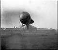
Wartime Barrage Balloon in the sportsfield of Burnage High School
Image: © Peter Ward
Taken: Unknown
0.09 miles
2
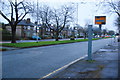
Speed camera on Kingsway
There is a 40mph speed limit on this road, but there are also frequent traffic lights to slow you down.
Image: © Bill Boaden
Taken: 27 Dec 2012
0.14 miles
3
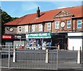
Pound Island Discount Store - Burnage
Image: © Anthony Parkes
Taken: 23 Jun 2014
0.16 miles
4
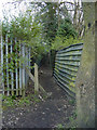
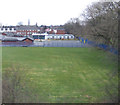
Bibby Lane, Burnage
Bibby Lane is an ancient path which once directed the public through farmland, it is now a dilapidated dark path through undergrowth linking Burnage Lane and Bournelea Avenue. Ancient cobbles are still visible at points.
Image: © Matthew Wilkinson
Taken: 13 Mar 2003
0.19 miles
5
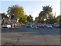
Kingsway (A34)
Looking south (towards Fidsbury and Cheadle) from the Mauldeth Road junction on Kingsway.
Image: © David Dixon
Taken: 28 Sep 2011
0.20 miles
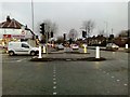
7
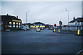
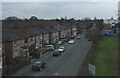
The junction of Mauldeth Road and Kingsway, Burnage
Taken in early morning light.
Image: © Bill Boaden
Taken: 27 Dec 2012
0.22 miles
8
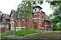
Santaidd, Burnage Lane, Manchester
A "wonderfully monstrous" Victorian villa (1887) representing the increasing influence of Manchester on the village of Burnage.
It has since been restored and converted into an unfeasibly large number of flats (probably).
Image: © Stephen Richards
Taken: 27 May 2016
0.22 miles