IMAGES TAKEN NEAR TO
Fog Lane, MANCHESTER, M19 1AY
Introduction
This page details the photographs taken nearby to Fog Lane, M19 1AY by members of the Geograph project.
The Geograph project started in 2005 with the aim of publishing, organising and preserving representative images for every square kilometre of Great Britain, Ireland and the Isle of Man.

There are currently over 7.5m images from over14,400 individuals and you can help contribute to the project by visiting https://www.geograph.org.uk
Image Map
Images are licensed for reuse under creativecommons.org/licenses/by-sa/2.0
Notes
- Clicking on the map will re-center to the selected point.
- The higher the marker number, the further away the image location is from the centre of the postcode.
Image Listing (55 Images Found)
Images are licensed for reuse under creativecommons.org/licenses/by-sa/2.0
Image
Details
Distance
1
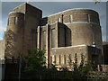
St Nicholas, Burnage
Built in 1931-2 (architects Welch, Cachemaille-Day & Lander).
Image: © S Parish
Taken: 22 Sep 2009
0.04 miles
2
Fog Lane, Bridge at Burnage Rail Station
Image: © David Dixon
Taken: 28 Sep 2011
0.04 miles
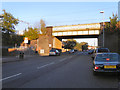
3
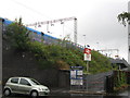
Railway Bridge, Fog Lane, Burnage
Immediately south of Burnage Station, on the Manchester Piccadilly to Manchester Airport & Crewe "Styal Loop" line.
Image: © Stephen Armstrong
Taken: 18 Jul 2011
0.04 miles
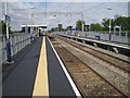
5
Burnage Station Entrance
The ramped entrance to the southbound platform 2 from Fog Lane. A First TransPennine Express train is speeding through on its way to Manchester Airport.
Image: © Stephen Armstrong
Taken: 18 Jul 2011
0.05 miles
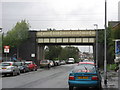
6
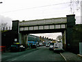
Railway bridge over Fog Lane
Looking west towards the shops on the far side of the bridge.
Image: © Slbs
Taken: Unknown
0.05 miles
7
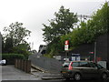
Burnage Station Entrance
The ramped entrance to the northbound platform 1 from Fog Lane.
Image: © Stephen Armstrong
Taken: 18 Jul 2011
0.05 miles
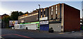
9
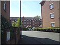
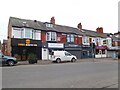
The Quadrant
New housing off Fog Lane.
Image: © Gerald England
Taken: 26 Apr 2021
0.05 miles
10
Burnage railway station
Opened in 1909 by the London & North Western Railway on the "Styal loop line" from Wilmslow to Manchester. View north towards Mauldeth Road and Manchester.
Image: © Nigel Thompson
Taken: 10 Jul 2010
0.07 miles