IMAGES TAKEN NEAR TO
Tanners Street, MANCHESTER, M18 8WT
Introduction
This page details the photographs taken nearby to Tanners Street, M18 8WT by members of the Geograph project.
The Geograph project started in 2005 with the aim of publishing, organising and preserving representative images for every square kilometre of Great Britain, Ireland and the Isle of Man.

There are currently over 7.5m images from over14,400 individuals and you can help contribute to the project by visiting https://www.geograph.org.uk
Image Map
Images are licensed for reuse under creativecommons.org/licenses/by-sa/2.0
Notes
- Clicking on the map will re-center to the selected point.
- The higher the marker number, the further away the image location is from the centre of the postcode.
Image Listing (195 Images Found)
Images are licensed for reuse under creativecommons.org/licenses/by-sa/2.0
Image
Details
Distance
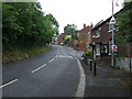
2
Tan Yard Brow
Named after an ancient tannery by Gore Brook.
Image: © Gerald England
Taken: 3 May 2011
0.03 miles
3
View from Tannery Way
Looking towards the site of the old tannery in the valley of Gore brook below its exit from Lower Gorton Reservoir and across the former Fallowfield Loop railway line and towards the Fitness centre Image on Wall Road.
Image: © Gerald England
Taken: 3 May 2011
0.04 miles
4
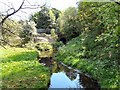
Gore Brook
From the bridge on Tan Yard Brow.
Image: © Gerald England
Taken: 3 May 2011
0.04 miles
5

Docklands Light Railway car at Debdale Park, Manchester
Car No 11 giving a demonstration to City Councillors etc. before Metrolink was introduced
Image: © Dr Neil Clifton
Taken: 14 Mar 1987
0.06 miles
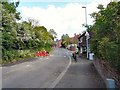
6
Tan Yard Brow
Part of an ancient North-South route but now restricted to prevent its use as a rat run. The lane is blocked off for through traffic at the bridge over Gore Brook. Southbound only a left turn is allowed onto the busy Hyde Road Image
Image: © Gerald England
Taken: 3 May 2011
0.08 miles
7

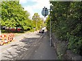
Google car on Tan Yard Brow
Presumably updating their imagery, this "Google car" was seen on Tan Yard Brow Image With roadworks on the street and the pavement in a distressed state, it was forced to follow a pedestrian forced on the road at a snail's pace before turning round as the lane is closed at the bridge over Gore Brook.
Image: © Gerald England
Taken: 3 May 2011
0.08 miles
8
Reservoir outfall
The outfall from Gorton Lower Reservoir at Debdale Park.
Image: © Gerald England
Taken: 3 May 2011
0.08 miles
9
Reservoir outfall
The outfall from Gorton Lower Reservoir at Debdale Park.
Image: © Gerald England
Taken: 3 May 2011
0.08 miles
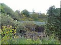
10
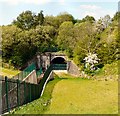
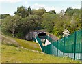
Bridge under Fallowfield Loop
Bridge on the route of the former Stockport Branch canal at Debdale Park under the Fallowfield Loop.
Image: © Gerald England
Taken: 3 May 2011
0.08 miles