IMAGES TAKEN NEAR TO
Havers Road, MANCHESTER, M18 8UN
Introduction
This page details the photographs taken nearby to Havers Road, M18 8UN by members of the Geograph project.
The Geograph project started in 2005 with the aim of publishing, organising and preserving representative images for every square kilometre of Great Britain, Ireland and the Isle of Man.

There are currently over 7.5m images from over14,400 individuals and you can help contribute to the project by visiting https://www.geograph.org.uk
Image Map (Loading...)


Getting Data...Please wait
Leaflet Map data © OpenStreetMap
Images are licensed for reuse under creativecommons.org/licenses/by-sa/2.0
Notes
- Clicking on the map will re-center to the selected point.
- The higher the marker number, the further away the image location is from the centre of the postcode.
Image Listing (162 Images Found)
Images are licensed for reuse under creativecommons.org/licenses/by-sa/2.0
Image
Details
Distance
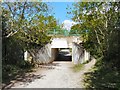
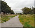
1
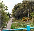
Stockport Canal Way
From the bridge on the former Fairfield to Fallowfield railway looking at the footpath and cycleway on the former route of the Stockport canal.
Image: © Gerald England
Taken: 24 Sep 2009
0.05 miles
2
Path junction by Tannery Way
Junction of the path along the route of the former Stockport Branch Canal and the Fallowfield Loop.
Image
Image: © Gerald England
Taken: 3 May 2011
0.06 miles
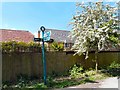
3
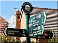
Stockport Branch Canal signpost
Signpost at the junction of the Stockport Branch Canal and the Fallowfield Loop Image
Image: © Gerald England
Taken: 3 May 2011
0.06 miles
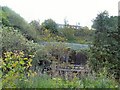
5
Bridge under Fallowfield Loop
Bridge on the route of the former Stockport Branch canal at Debdale Park under the Fallowfield Loop.
Image: © Gerald England
Taken: 3 May 2011
0.09 miles
6
Tan Yard Brow
Named after an ancient tannery by Gore Brook.
Image: © Gerald England
Taken: 3 May 2011
0.09 miles
7
View from Tannery Way
Looking towards the site of the old tannery in the valley of Gore brook below its exit from Lower Gorton Reservoir and across the former Fallowfield Loop railway line and towards the Fitness centre Image on Wall Road.
Image: © Gerald England
Taken: 3 May 2011
0.10 miles
8
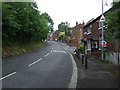
Footpath to Fairfield
Along the line of the railway from Fairfield to Fallowfield.
Image: © Gerald England
Taken: 24 Sep 2009
0.12 miles
9
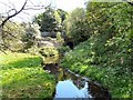
Gore Brook
From the bridge on Tan Yard Brow.
Image: © Gerald England
Taken: 3 May 2011
0.13 miles
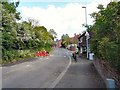
10
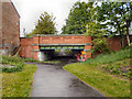
Abbey Hey Lane Bridge
The bridge at Abbey Hey Lane, on the route of the former Stockport Branch Canal.
Image: © David Dixon
Taken: 16 May 2011
0.13 miles