IMAGES TAKEN NEAR TO
Abbey Hey Lane, MANCHESTER, M18 8RL
Introduction
This page details the photographs taken nearby to Abbey Hey Lane, M18 8RL by members of the Geograph project.
The Geograph project started in 2005 with the aim of publishing, organising and preserving representative images for every square kilometre of Great Britain, Ireland and the Isle of Man.

There are currently over 7.5m images from over14,400 individuals and you can help contribute to the project by visiting https://www.geograph.org.uk
Image Map
Images are licensed for reuse under creativecommons.org/licenses/by-sa/2.0
Notes
- Clicking on the map will re-center to the selected point.
- The higher the marker number, the further away the image location is from the centre of the postcode.
Image Listing (32 Images Found)
Images are licensed for reuse under creativecommons.org/licenses/by-sa/2.0
Image
Details
Distance
1
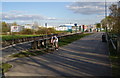
The entrance to Wright Robinson College
The entrance crosses the line of a former railway, now used as a leisure track. It looks like the original bridge is still in place but the cutting has been filled in below it. Wright Robinson College has been completely rebuilt, presumably as part of Building Schools for the Future.
Image: © Bill Boaden
Taken: 21 Apr 2010
0.07 miles
2

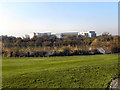
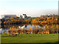
Wright Robinson Sports College
View looking across Gorton Upper Reservoir to Wright Robinson Sports College.
Image: © Peter McDermott
Taken: 30 Nov 2014
0.09 miles
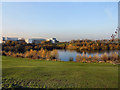
3

Wright Robinson Sports College
Viewed across Fairfield golf course and Gorton Upper Reservoir from Kings Road.
Image: © Gerald England
Taken: 28 Mar 2011
0.09 miles
4
Two for Joy
The footpath to Fairfield along the old railway. There is a magpie on the path and another in the tree.
Image: © Gerald England
Taken: 12 Feb 2009
0.10 miles
5
Wright Robinson Sports College
Looking across the Gorton Upper Reservoir towards the Wright Robinson Sports College.
Image: © David Dixon
Taken: 16 Nov 2011
0.11 miles
6
Wright Robinson College
From the footpath from Debdale Park to Abbey Hey.
Image: © Gerald England
Taken: 12 Feb 2009
0.11 miles
7
Gorton Upper Reservoir and Wright Robinson Sports College
Looking across part of the Fairfield Golf Course towards the reservoir and school
Image: © David Dixon
Taken: 16 Nov 2011
0.15 miles
8
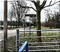
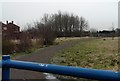
A crossing of paths
Just by the entrance to the Elisabeth Svendsen Trust Donkey Sanctuary is a footpath crossroads. Behind us is Greenfold leading into Abbey Hey. Ahead is Debdale Park. Left leads along the old railway line to Fairfield. Right goes along the old railway towards Gorton.
Image: © Gerald England
Taken: 12 Feb 2009
0.15 miles
9
Wright Robinson Sports College
The Wright Robinson Sports College and the Gorton Upper Reservoir.
See Image] for a wide-angle view
Image: © David Dixon
Taken: 16 Nov 2011
0.15 miles
10
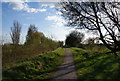
Path from Fairfield to Abbey Hey
This is along the route of a former railway line. I think it was originally used for goods traffic bypassing Manchester.
Image: © Bill Boaden
Taken: 21 Apr 2010
0.16 miles