IMAGES TAKEN NEAR TO
Franklyn Road, MANCHESTER, M18 8QX
Introduction
This page details the photographs taken nearby to Franklyn Road, M18 8QX by members of the Geograph project.
The Geograph project started in 2005 with the aim of publishing, organising and preserving representative images for every square kilometre of Great Britain, Ireland and the Isle of Man.

There are currently over 7.5m images from over14,400 individuals and you can help contribute to the project by visiting https://www.geograph.org.uk
Image Map
Images are licensed for reuse under creativecommons.org/licenses/by-sa/2.0
Notes
- Clicking on the map will re-center to the selected point.
- The higher the marker number, the further away the image location is from the centre of the postcode.
Image Listing (19 Images Found)
Images are licensed for reuse under creativecommons.org/licenses/by-sa/2.0
Image
Details
Distance
1
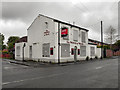
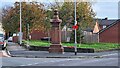
The Prince of Wales
The Prince of Wales; former public house on Abbey Hey Lane.
Image: © David Dixon
Taken: 16 May 2011
0.13 miles
2
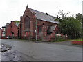
Church of St George the Martyr, Abbey Hey
The former Anglican Church of St George the Martyr at Abbey Hey, was founded in 1882 and closed in 2007.
Image: © David Dixon
Taken: 16 May 2011
0.13 miles
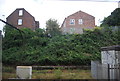
4
Corner of Abbey Hey Lane and Vine Street
Image: © Gerald England
Taken: 5 Aug 2016
0.13 miles
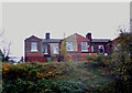
8

Gorton station booking office
Designed to be vandal resistant and fireproof - with good reason.
Image: © Peter Whatley
Taken: 24 Mar 1989
0.19 miles
9
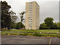
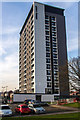
Abbey Court
Abbey Court; a block of high rise flats on Hollybush Street.
Image: © David Dixon
Taken: 16 May 2011
0.20 miles
10
Abbey Court
Abbey Court in Abbey Hey.
Image: © Peter McDermott
Taken: 20 Apr 2015
0.20 miles