IMAGES TAKEN NEAR TO
Highmead Street, MANCHESTER, M18 8PJ
Introduction
This page details the photographs taken nearby to Highmead Street, M18 8PJ by members of the Geograph project.
The Geograph project started in 2005 with the aim of publishing, organising and preserving representative images for every square kilometre of Great Britain, Ireland and the Isle of Man.

There are currently over 7.5m images from over14,400 individuals and you can help contribute to the project by visiting https://www.geograph.org.uk
Image Map
Images are licensed for reuse under creativecommons.org/licenses/by-sa/2.0
Notes
- Clicking on the map will re-center to the selected point.
- The higher the marker number, the further away the image location is from the centre of the postcode.
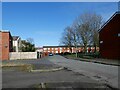
Image Listing (116 Images Found)
Images are licensed for reuse under creativecommons.org/licenses/by-sa/2.0
Image
Details
Distance
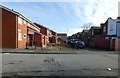
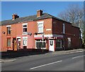
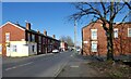
3
Sheerness Street
Off Chapman Street. Originally this was Sherborne Street.
Image: © Gerald England
Taken: 26 Feb 2021
0.07 miles
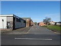
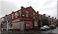
4
Craig's Barbers
On the corner of Chapman Street and Sheerness Street.
Image: © Gerald England
Taken: 26 Feb 2021
0.07 miles
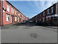
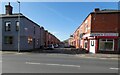
6
Chapman Street
Crossing Jessop Street.
Image: © Gerald England
Taken: 26 Feb 2021
0.09 miles