IMAGES TAKEN NEAR TO
Seathwaite Walk, MANCHESTER, M18 8ND
Introduction
This page details the photographs taken nearby to Seathwaite Walk, M18 8ND by members of the Geograph project.
The Geograph project started in 2005 with the aim of publishing, organising and preserving representative images for every square kilometre of Great Britain, Ireland and the Isle of Man.

There are currently over 7.5m images from over14,400 individuals and you can help contribute to the project by visiting https://www.geograph.org.uk
Image Map
Images are licensed for reuse under creativecommons.org/licenses/by-sa/2.0
Notes
- Clicking on the map will re-center to the selected point.
- The higher the marker number, the further away the image location is from the centre of the postcode.
Image Listing (102 Images Found)
Images are licensed for reuse under creativecommons.org/licenses/by-sa/2.0
Image
Details
Distance
1

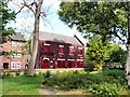
Gorton Rushcart
Gorton Morris with their rushcart near the Suburban PH. The rushes were cut the previous weekend in the hills and were bundled, trimmed, assembled onto the cart behind the pub during the week. On the Saturday the decoration was added and the rushcart was paraded around the streets of Gorton by Gorton Morris in their clogs joined by invited teams from all over the country.
Image: © John M
Taken: Unknown
0.12 miles
2
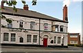
Gardeners Arms
This pub on Gorton Lane looked closed when I took this photograph but it was open when I passed it some six weeks later.
Image: © Gerald England
Taken: 3 May 2011
0.14 miles
3
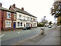
Gardeners Arms
On the corner of Gorton Lane and Borwell Street.
Image
Image: © Gerald England
Taken: 21 Oct 2017
0.14 miles
4
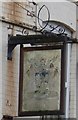
Sign of the Gardeners Arms
The rather faded sign for the Gardeners Arms Image
Image: © Gerald England
Taken: 21 Oct 2017
0.14 miles
5
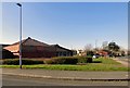
Eastlands/Belle Vue House
The building which used to be a community resource centre is to be demolished.
Image: © Gerald England
Taken: 26 Feb 2019
0.14 miles
6
St James Conservative Club
Viewed from the grounds of St James' church.
Image: © Gerald England
Taken: 3 May 2011
0.14 miles
7
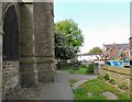
Cambert Lane
From the side of St James' Image looking down Cambert Lane towards Borwell Street.
Image: © Gerald England
Taken: 3 May 2011
0.14 miles

9
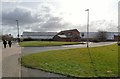
The Suburban off Garratt Way
Garratt Way from the corner of Robertson Close Image
Originally the Suburban Hotel and dating from 1881. It is the only building in the vicinity that has survived while all around it has been replaced in modern times. In the background is the Tesco superstore.
Image
Old photos of the pub can be found at http://web.archive.org/web/20160412001802/http://homepage.ntlworld.com/alscot1/Suburban.htm
In 2009 it was a J.W.Lees pub Image, but is no longer part of its portfolio. The car park was coned-off and doors and windows shuttered when I took this photo on a Monday morning. Whether it was just closed at that particular time or has permanently closed I couldn't be certain.
Image: © Gerald England
Taken: 30 Mar 2015
0.15 miles
10
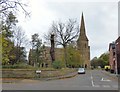
St James Parish Church, Gorton
The grade II listed church https://historicengland.org.uk/listing/the-list/list-entry/1254833 was built in 1871. It was endowed by Charles Beyer, engineer and partner in the locomotive-building firm Beyer and Peacock whose works were in Gorton.
Now St James' Church is a local ecumenical partnership between The Church of England and the Methodist Church Image and forms part of the Gorton Team Ministry which also includes Emmanuel Church, West Gorton and St. Philip's Church, Gorton.
Image: © Gerald England
Taken: 21 Oct 2017
0.15 miles