IMAGES TAKEN NEAR TO
Crossley Street, MANCHESTER, M18 8BA
Introduction
This page details the photographs taken nearby to Crossley Street, M18 8BA by members of the Geograph project.
The Geograph project started in 2005 with the aim of publishing, organising and preserving representative images for every square kilometre of Great Britain, Ireland and the Isle of Man.

There are currently over 7.5m images from over14,400 individuals and you can help contribute to the project by visiting https://www.geograph.org.uk
Image Map
Images are licensed for reuse under creativecommons.org/licenses/by-sa/2.0
Notes
- Clicking on the map will re-center to the selected point.
- The higher the marker number, the further away the image location is from the centre of the postcode.
Image Listing (75 Images Found)
Images are licensed for reuse under creativecommons.org/licenses/by-sa/2.0
Image
Details
Distance
1
Shiloh House
Home of the Manchester City Chapel, an Assemblies of God congregation on Crossley Street.
Image: © Gerald England
Taken: 22 Sep 2010
0.06 miles
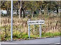
3

Gorton Park
Public Park off Belle Vue Street looking towards Queensland Street.
Image: © Gerald England
Taken: 22 Sep 2010
0.14 miles
4
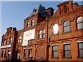
Gorton Baths
This is the old Gorton Baths, one of the last old landmarks of Gorton. An interesting building close to Gorton Park, it was also used as a gymnastic centre, but now sadly unused and in bad condition. Will probably be demolished soon. A sad end to a proud building.
Image: © GARY TAYLOR
Taken: 8 Feb 2005
0.14 miles
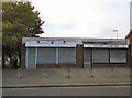
5
Queensland Road
The site of Gorton Baths. Despite being a grade II listed building, Gorton Baths was allowed to fall into disrepair and was demolished in 2007.
Image: © Gerald England
Taken: 19 Nov 2011
0.15 miles
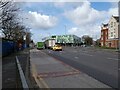
6
Site of Gorton Baths
Despite being a grade II listed building, Gorton Baths was allowed to fall into disrepair and was demolished in 2007. Mecca Bingo across the Hyde Road on the former site of Belle Vue Zoo can be seen in the background.
Image: © Gerald England
Taken: 19 Nov 2011
0.15 miles
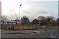
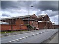
7
Hyde Road
The A57 at Belle Vue. Behind the traffic lights is the Hideout Youth Zone https://www.hideoutyouthzone.org/about-us/ opened in 2020 on the site of the former Gorton Swimming Baths Image
Image: © Gerald England
Taken: 15 Mar 2021
0.15 miles
8
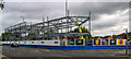
Belle Vue
Development at Belle Vue.
Image: © Peter McDermott
Taken: 15 Jun 2019
0.16 miles
9
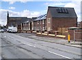
New Housing on Gorton Lane
A new housing development on the former industrial land between Gorton Monastery and the railway. This site was first used as a Chemical works in the late 1800s alongside housing and a school and then In the 1900s a gas works was added to the site. In 1907, the chemical works was replaced by Crossley Motor Works, which expanded over time across the whole site. These works had also then closed by 1960, and replaced by warehousing (http://goo.gl/muxoVY planning application).
Image: © David Dixon
Taken: 23 Mar 2015
0.17 miles
10
Industrial Premises on Gorton Lane
This large former factory (?) stretching along Gorton Lane is Manchester City Council's Hammerstone Lane depot (the entrance is on Hammerstone Lane). There is a pub on the corner called "Steelworks Tavern" - perhaps that may be a clue to its former use.
Image: © David Dixon
Taken: 23 Mar 2015
0.17 miles