IMAGES TAKEN NEAR TO
Horbury Avenue, MANCHESTER, M18 7WR
Introduction
This page details the photographs taken nearby to Horbury Avenue, M18 7WR by members of the Geograph project.
The Geograph project started in 2005 with the aim of publishing, organising and preserving representative images for every square kilometre of Great Britain, Ireland and the Isle of Man.

There are currently over 7.5m images from over14,400 individuals and you can help contribute to the project by visiting https://www.geograph.org.uk
Image Map
Images are licensed for reuse under creativecommons.org/licenses/by-sa/2.0
Notes
- Clicking on the map will re-center to the selected point.
- The higher the marker number, the further away the image location is from the centre of the postcode.
Image Listing (12 Images Found)
Images are licensed for reuse under creativecommons.org/licenses/by-sa/2.0
Image
Details
Distance
1
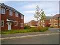
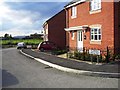
Rawsthorne Avenue, Gorton
Houses at Rawsthorne Avenue (M18 7GB), in the Gorton area of Manchester, close to the city's boundary with Reddish in the Metropolitan Borough of Stockport.
Image: © Steven Haslington
Taken: 18 Apr 2011
0.15 miles
3
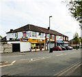
Shops at Ryder Brow
Opposite Ryder Brow station are a group of shops including an off-licence that appears to be both a Premier store and a Raja Bros store which I'd always thought were separate franchises. Also there is an Internet Cafe, a launderette and an Afro-Caribbean food and spice shop.
Streetview imagery from 2008 shows the internet cafe as a vacant property, the launderette as an off-licence and the end shop as being a part of the Manchester College of Customised Studies. By 2011 the college had closed. The cafe and Afro-Caribbean shop had opened by 2014 but the launderette not until 2016.
Image: © Gerald England
Taken: 17 May 2018
0.19 miles
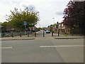
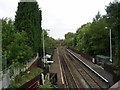
5
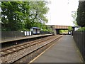
Ryder Brow station
The station was opened by British Rail in 1985. Many of the trains that pass through don't stop.
Image: © Gerald England
Taken: 17 May 2018
0.22 miles
6
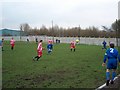
Abbey Hey v Ramsbottom United
A match in the North West Counties league. The Manchester to Sheffield railway runs just the other side of the fence.
Image: © Bill Boaden
Taken: 5 Feb 2005
0.23 miles
7
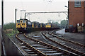
Reddish Loco Depot
Rows of class 76 1500v DC electric locomotives stand beside the depot buildings. Built for the Woodhead route in the early 1950's, the decision in the late 1950's to go for 25Kv AC traction on future electrifications made them obsolescent overnight. The Woodhead route closed in 1981 and the class were withdrawn en-masse in July of that year.
Image: © Martin Addison
Taken: Unknown
0.23 miles
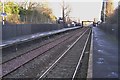
8
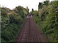
Ryder Brow Station
A view to the west from the road bridge carrying Levenshulme Road over the railway by Ryder Brow Station, Gorton, Manchester. SJ88619556.
Image: © Keith Williamson
Taken: 28 Sep 2005
0.23 miles
9
Ryder Brow railway station, Greater Manchester
Opened in 1985 by British Rail on the line from Manchester to Chinley.
View south east towards Reddish North and Chinley.
Image: © Nigel Thompson
Taken: 27 Nov 2010
0.24 miles