IMAGES TAKEN NEAR TO
Rainshaw Lane, MANCHESTER, M18 7TE
Introduction
This page details the photographs taken nearby to Rainshaw Lane, M18 7TE by members of the Geograph project.
The Geograph project started in 2005 with the aim of publishing, organising and preserving representative images for every square kilometre of Great Britain, Ireland and the Isle of Man.

There are currently over 7.5m images from over14,400 individuals and you can help contribute to the project by visiting https://www.geograph.org.uk
Image Map
Images are licensed for reuse under creativecommons.org/licenses/by-sa/2.0
Notes
- Clicking on the map will re-center to the selected point.
- The higher the marker number, the further away the image location is from the centre of the postcode.
Image Listing (11 Images Found)
Images are licensed for reuse under creativecommons.org/licenses/by-sa/2.0
Image
Details
Distance
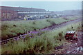
1

Abbey Hey v Ramsbottom United
A match in the North West Counties league. The Manchester to Sheffield railway runs just the other side of the fence.
Image: © Bill Boaden
Taken: 5 Feb 2005
0.10 miles
2

Abbey Hey are playing at home
A match in the North West Counties league.
Image: © Bill Boaden
Taken: 5 Feb 2005
0.12 miles
3
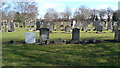
Headstones in Gorton Cemetery
On the photographer's first birthday his grandfather was buried here.
His memorial is the modest headstone at the centre of the picture.
Image: © Geoff Royle
Taken: 4 Mar 2010
0.19 miles
4
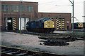
Reddish Loco Depot
Rows of class 76 1500v DC electric locomotives stand beside the depot buildings. Built for the Woodhead route in the early 1950's, the decision in the late 1950's to go for 25Kv AC traction on future electrifications made them obsolescent overnight. The Woodhead route closed in 1981 and the class were withdrawn en-masse in July of that year.
Image: © Martin Addison
Taken: Unknown
0.20 miles
5
Reddish Locomotive Depot, 1981
By 2015, this had mostly become a housing estate.
Image: © Nigel Thompson
Taken: 22 Jul 1981
0.21 miles

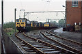
7
Reddish Loco Depot
40055 sits outside Reddish Depot. This shed was constructed in 1954 to be the primary maintenance depot for the 1500v electric locomotives operating over the Woodhead Route between Manchester and Sheffield via Penistone. It also maintained the Manchester - Glossop/Hadfield electric units, one of which can be seen on the right of the photo. The Woodhead Route closed in 1981 and the depot closed in 1983. Although the buildings were subsequently demolished, their footprint is still visible on Google maps at this time.
Image: © Martin Addison
Taken: Unknown
0.22 miles
8

Gorton Cemetery
View looking across Gorton Cemetery.
Image: © Peter McDermott
Taken: 23 Aug 2014
0.22 miles
9

Rawsthorne Avenue, Gorton
Houses at Rawsthorne Avenue (M18 7GB), in the Gorton area of Manchester, close to the city's boundary with Reddish in the Metropolitan Borough of Stockport.
Image: © Steven Haslington
Taken: 18 Apr 2011
0.24 miles
10
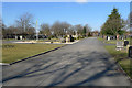
Main driveway in Gorton Cemetery
The conservationists have lost the fight. Image
The chapel has been replaced by the memorial of recycled stone blocks in the centre of the picture.
The cemetery main gate which faces Thornwood Avenue is at the far end of the drive.
Image: © Geoff Royle
Taken: 4 Mar 2010
0.24 miles