IMAGES TAKEN NEAR TO
Wembley Road, MANCHESTER, M18 7ST
Introduction
This page details the photographs taken nearby to Wembley Road, M18 7ST by members of the Geograph project.
The Geograph project started in 2005 with the aim of publishing, organising and preserving representative images for every square kilometre of Great Britain, Ireland and the Isle of Man.

There are currently over 7.5m images from over14,400 individuals and you can help contribute to the project by visiting https://www.geograph.org.uk
Image Map
Images are licensed for reuse under creativecommons.org/licenses/by-sa/2.0
Notes
- Clicking on the map will re-center to the selected point.
- The higher the marker number, the further away the image location is from the centre of the postcode.
Image Listing (18 Images Found)
Images are licensed for reuse under creativecommons.org/licenses/by-sa/2.0
Image
Details
Distance
1
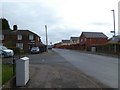
Melland Road
From the end of Balmain Avenue.
Image: © Gerald England
Taken: 7 Mar 2020
0.18 miles
4
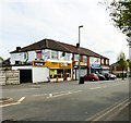
Shops at Ryder Brow
Opposite Ryder Brow station are a group of shops including an off-licence that appears to be both a Premier store and a Raja Bros store which I'd always thought were separate franchises. Also there is an Internet Cafe, a launderette and an Afro-Caribbean food and spice shop.
Streetview imagery from 2008 shows the internet cafe as a vacant property, the launderette as an off-licence and the end shop as being a part of the Manchester College of Customised Studies. By 2011 the college had closed. The cafe and Afro-Caribbean shop had opened by 2014 but the launderette not until 2016.
Image: © Gerald England
Taken: 17 May 2018
0.21 miles
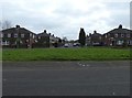
5
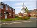
Rawsthorne Avenue, Gorton
Houses at Rawsthorne Avenue (M18 7GB), in the Gorton area of Manchester, close to the city's boundary with Reddish in the Metropolitan Borough of Stockport.
Image: © Steven Haslington
Taken: 18 Apr 2011
0.21 miles
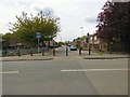
6
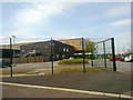
Gorton Education Village
Gorton Education Village, a secondary-level school in the Gorton area of Manchester, England.
Image: © Steven Haslington
Taken: 18 Apr 2011
0.22 miles
7
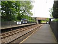
Ryder Brow station
The station was opened by British Rail in 1985. Many of the trains that pass through don't stop.
Image: © Gerald England
Taken: 17 May 2018
0.23 miles
8
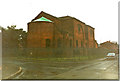
Our Lady & St Thomas Church, Gorton
This picture was taken on a rainy day in 1994. It is an awful picture of this church by Sir Walter Tapper.
Image: © John Salmon
Taken: Unknown
0.23 miles
9
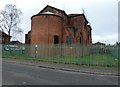
Mount Olivet Church
The Grade II listed https://historicengland.org.uk/listing/the-list/list-entry/1380065 Church of Our Lady and St Thomas of Canterbury was built at the bequest of Mrs Angelina Frances Clarke, who chose the dedication and form of decoration. The administration of Mrs Clarke's bequest was entrusted to the Community of the Resurrection at Mirfield who appointed their own architect, Walter Tapper, to prepare the design. It was built between 1926 and 1928. It was extended in 1983 with a narthex by Buttress Fuller architects.
In 2005 it became the Mount Olivet Apostolic Church which then closed in 2015. The presence of scaffolding suggests the building is being looked after, possibly for conversion to apartments.
Image: © Gerald England
Taken: 7 Mar 2020
0.23 miles
10
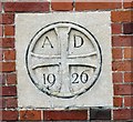
AD 1926
Date stone on Mount Olivet Church Image
Image: © Gerald England
Taken: 7 Mar 2020
0.23 miles