IMAGES TAKEN NEAR TO
Wembley Road, MANCHESTER, M18 7DT
Introduction
This page details the photographs taken nearby to Wembley Road, M18 7DT by members of the Geograph project.
The Geograph project started in 2005 with the aim of publishing, organising and preserving representative images for every square kilometre of Great Britain, Ireland and the Isle of Man.

There are currently over 7.5m images from over14,400 individuals and you can help contribute to the project by visiting https://www.geograph.org.uk
Image Map
Images are licensed for reuse under creativecommons.org/licenses/by-sa/2.0
Notes
- Clicking on the map will re-center to the selected point.
- The higher the marker number, the further away the image location is from the centre of the postcode.
Image Listing (6 Images Found)
Images are licensed for reuse under creativecommons.org/licenses/by-sa/2.0
Image
Details
Distance
1

Gorton Education Village
Gorton Education Village, a secondary-level school in the Gorton area of Manchester, England.
Image: © Steven Haslington
Taken: 18 Apr 2011
0.03 miles
2
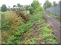
Nico Ditch
Looking west along Nico Ditch near Levenshulme, Manchester. The public footpath seen here runs between the ditch on the left and Mellands Playing Field which lies beyond the fence on the right. About 200-300 metres of the ditch survive here and little elsewhere. This ditch is believed to have been a defensive earthwork dug in a single night as protection against the Danish invasion of 869-870 AD. It varied in width and depth, but averaged between 2 and 2.5 metres deep, and extended for over five miles in length between marshes in Fallowfield and Audenshaw. SJ88249487.
Image: © Keith Williamson
Taken: 12 Oct 2005
0.14 miles
3
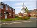
Rawsthorne Avenue, Gorton
Houses at Rawsthorne Avenue (M18 7GB), in the Gorton area of Manchester, close to the city's boundary with Reddish in the Metropolitan Borough of Stockport.
Image: © Steven Haslington
Taken: 18 Apr 2011
0.15 miles

5
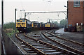
Reddish Loco Depot
Rows of class 76 1500v DC electric locomotives stand beside the depot buildings. Built for the Woodhead route in the early 1950's, the decision in the late 1950's to go for 25Kv AC traction on future electrifications made them obsolescent overnight. The Woodhead route closed in 1981 and the class were withdrawn en-masse in July of that year.
Image: © Martin Addison
Taken: Unknown
0.25 miles
6
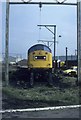
On the shed
Class 40 40179 is waiting attention outside Reddish shed. At this time Reddish had heavy lifting gear as well as tyre reprofiling equipment. It was quite a busy engineering depot repairing and servicing locomotives for the North West area of British Rail as well as the base for the Woodhead line class 76 electric locomotives. With the closure of the Woodhead line in early 1981 the depot lost most of its work and was shut. The buildings have all been razed to the ground. Even the freight line that went by the depot has closed and been lifted.
Image: © roger geach
Taken: Unknown
0.25 miles