IMAGES TAKEN NEAR TO
Lockton Court, MANCHESTER, M1 7JP
Introduction
This page details the photographs taken nearby to Lockton Court, M1 7JP by members of the Geograph project.
The Geograph project started in 2005 with the aim of publishing, organising and preserving representative images for every square kilometre of Great Britain, Ireland and the Isle of Man.

There are currently over 7.5m images from over14,400 individuals and you can help contribute to the project by visiting https://www.geograph.org.uk
Image Map
Images are licensed for reuse under creativecommons.org/licenses/by-sa/2.0
Notes
- Clicking on the map will re-center to the selected point.
- The higher the marker number, the further away the image location is from the centre of the postcode.
Image Listing (419 Images Found)
Images are licensed for reuse under creativecommons.org/licenses/by-sa/2.0
Image
Details
Distance
1
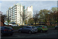
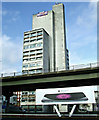
Lockton Court
A residential towerblock off Grosvenor Street.
Image: © Thomas Nugent
Taken: 10 Nov 2014
0.01 miles
2
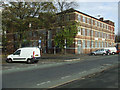
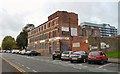
Grosvenor Street
An industrial building at the corner of Penfield Close, which is on the left.
Image: © Thomas Nugent
Taken: 10 Nov 2014
0.05 miles
3
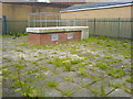
To the bunker
Located in Lockton Close, Ardwick this innocent looking structure provides an entry point to the tunnels of the Guardian Exchange bunker. See also Image and Image
Image: © Keith Williamson
Taken: 20 May 2009
0.05 miles
5
Manchester University
The Maths and Social Sciences building, with Mancunian Way in the foreground.
Image: © Thomas Nugent
Taken: 10 Nov 2014
0.05 miles
6
Crown Knitwear
Cotton Mill on Grosvenor Street.
Image: © Gerald England
Taken: 18 Oct 2010
0.05 miles
8
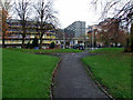
Small park
A small park in what appears to be a gap site at the corner of Grosvenor Street and Lockton Close.
Image: © Thomas Nugent
Taken: 10 Nov 2014
0.06 miles
9
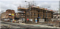
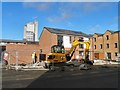
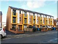
Grosvenor Street
New building alongside Grosvenor Street.
Image: © Peter McDermott
Taken: 17 Apr 2017
0.06 miles
10
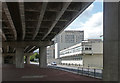
Mancunian Way, Manchester
Concreteophobes look away now. The Mancunian Way (A57(M)) runs from Hulme to Ardwick and serves as part of the city's inner ring road. Mostly built in 1964-67 by the council's City Engineers and G. Maunsell & Partners, it was extended east to Ardwick in 1992.
On the right are former University of Manchester Institute for Science and Technology buildings. The prominent one is the Faraday Tower (Image]).
Image: © Stephen Richards
Taken: 23 Jul 2011
0.07 miles