IMAGES TAKEN NEAR TO
Grosvenor Street, MANCHESTER, M1 7HL
Introduction
This page details the photographs taken nearby to Grosvenor Street, M1 7HL by members of the Geograph project.
The Geograph project started in 2005 with the aim of publishing, organising and preserving representative images for every square kilometre of Great Britain, Ireland and the Isle of Man.

There are currently over 7.5m images from over14,400 individuals and you can help contribute to the project by visiting https://www.geograph.org.uk
Image Map
Images are licensed for reuse under creativecommons.org/licenses/by-sa/2.0
Notes
- Clicking on the map will re-center to the selected point.
- The higher the marker number, the further away the image location is from the centre of the postcode.
Image Listing (348 Images Found)
Images are licensed for reuse under creativecommons.org/licenses/by-sa/2.0
Image
Details
Distance
1
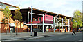
Sugden Sports Centre
On Grosvenor Street http://www.sugdensportscentre.com/ .
Image: © Thomas Nugent
Taken: 10 Nov 2014
0.03 miles
2
Grosvenor Street
At Upper Brook Street.
See also Image
Image: © Thomas Nugent
Taken: 10 Nov 2014
0.03 miles
3
Grosvenor Street
Looking towards the A34 Upper Brook Street.
See also Image
Image: © Thomas Nugent
Taken: 10 Nov 2014
0.03 miles
4
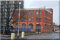
The North Western Museum of Science and Industry, Manchester
Opened in 1969, the North Western Museum of Science and Industry was already outgrowing its temporary premises on Grosvenor Street, Chorlton-on-Medlock by the time this photograph was taken in December 1978. When the former Liverpool Road Station, one of Manchester's most important historic sites, closed in 1975, Greater Manchester Council agreed to purchase it to become the Museum's new home. The Museum opened at its new (and still current) site on 15 September 1983.
http://www.mosi.org.uk/ - Museum of Science and Industry
Image: © David Dixon
Taken: Unknown
0.04 miles
5

Mancunian Way over Brook Street
On the right is A57(M) Mancunian Way. On the left is the westbound slip road from Brook Street.
Image: © Gerald England
Taken: 15 Jun 2018
0.04 miles
6
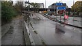
Sizeable puddle on A57(M) slip road
The westbound slip road from the A34.
Image: © Bradley Michael
Taken: 9 Nov 2015
0.04 miles
8

Grosvenor Street
Sidney Street is on the left.
Image: © Thomas Nugent
Taken: 10 Nov 2014
0.04 miles
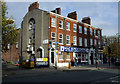
9
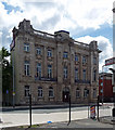
97 Grosvenor Street, Manchester
Typically florid Edwardian Baroque, entirely clad in terracotta. Fluted Ionic columns, rustication, swags, aprons, keystones - the decorative details are laid on thickly, but not overdone. Built c1910. Grade II listed.
Built for a friendly society, it is currently known as Oddfellows Hall and houses the University of Manchester's language centre.
Image: © Stephen Richards
Taken: 23 Jul 2011
0.05 miles
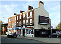
10
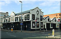
Pub Zoo
Two pubs on Grosvenor Street http://www.pubzoomanchester.co.uk/ .
See also Image
Image: © Thomas Nugent
Taken: 10 Nov 2014
0.05 miles