IMAGES TAKEN NEAR TO
Nobel Way, MANCHESTER, M1 7FD
Introduction
This page details the photographs taken nearby to Nobel Way, M1 7FD by members of the Geograph project.
The Geograph project started in 2005 with the aim of publishing, organising and preserving representative images for every square kilometre of Great Britain, Ireland and the Isle of Man.

There are currently over 7.5m images from over14,400 individuals and you can help contribute to the project by visiting https://www.geograph.org.uk
Image Map
Images are licensed for reuse under creativecommons.org/licenses/by-sa/2.0
Notes
- Clicking on the map will re-center to the selected point.
- The higher the marker number, the further away the image location is from the centre of the postcode.
Image Listing (836 Images Found)
Images are licensed for reuse under creativecommons.org/licenses/by-sa/2.0
Image
Details
Distance
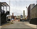
1
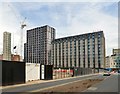
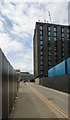
Brancaster Road
Leading past the Circle Square development on the site of the former BBC Manchester studios. Already built is the Vita student accommodation block.
Image: © Gerald England
Taken: 15 Jun 2018
0.02 miles
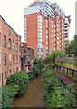
2
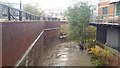
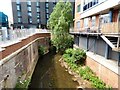
River Medlock, looking downstream
The river was experiencing higher levels of water than usual.
Image: © Bradley Michael
Taken: 9 Nov 2015
0.02 miles
3
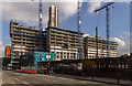
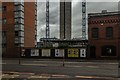
Circle Square
The Circle Square development on the old BBC Oxford Road site in Manchester.
Image: © Peter McDermott
Taken: 15 Oct 2016
0.02 miles
4
Circle Square
The Circle Square development on the old BBC Oxford Road site in Manchester.
Image: © Peter McDermott
Taken: 15 Oct 2016
0.03 miles
5
Vita student accommodation
On the Circle Square development of the site of the former BBC Manchester studios viewed from Princess Street.
Image: © Gerald England
Taken: 15 Jun 2018
0.03 miles
6
River Medlock
Downstream from Princess Street.
Image: © Gerald England
Taken: 15 Jun 2018
0.03 miles
7
Circle Square
The Circle Square development on the old BBC Oxford Road site in Manchester.
Image: © Peter McDermott
Taken: 10 Jul 2016
0.03 miles
8
Rochdale canal after clean up (from Oxford road)
Image: © Antony McCann
Taken: 1 Sep 2006
0.03 miles
9
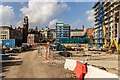
Circle Square development
From 1974 to 2012 this area was occupied by buildings belonging to BBC Manchester. When the BBC moved out to MediaCityUK and the main building demolished it became a car park. It is now being transformed by the Circle Square development.
Image: © Gerald England
Taken: 15 Jun 2018
0.03 miles
10
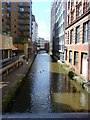
River Medlock
From Charles Street bridge. The large apartment block is Montana House on Princess Street.
Image: © Gerald England
Taken: 2 Jul 2012
0.03 miles