IMAGES TAKEN NEAR TO
Oxford Road, MANCHESTER, M1 7EE
Introduction
This page details the photographs taken nearby to Oxford Road, M1 7EE by members of the Geograph project.
The Geograph project started in 2005 with the aim of publishing, organising and preserving representative images for every square kilometre of Great Britain, Ireland and the Isle of Man.

There are currently over 7.5m images from over14,400 individuals and you can help contribute to the project by visiting https://www.geograph.org.uk
Image Map (290 Images)


Getting Data...Please wait
Leaflet Map data © OpenStreetMap
Images are licensed for reuse under creativecommons.org/licenses/by-sa/2.0
Notes
- Clicking on the map will re-center to the selected point.
- The higher the marker number, the further away the image location is from the centre of the postcode.
Image Listing (290 Images Found)
Images are licensed for reuse under creativecommons.org/licenses/by-sa/2.0
Image
Details
Distance
1
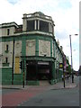
Former Grosvenor Picture Palace, Oxford Road, Manchester
Now a pub called The Footage.
Image: © Christopher Hilton
Taken: 25 Jul 2013
0.01 miles
2
Former Grosvenor Picture Palace, Oxford Road, Manchester
Now a pub called The Footage.
Image: © Christopher Hilton
Taken: 25 Jul 2013
0.01 miles
3
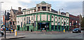
The Footage
The Footage, previously the Grosvenor Picture Palace.
Image: © Peter McDermott
Taken: 1 Nov 2014
0.01 miles
4
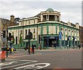
The Grosvenor Picture Palace now Footage
Former Cinema at the corner of Oxford Road and Grosvenor Street. The Grade II listed building https://www.britishlistedbuildings.co.uk/101218431-former-grosvenor-picture-palace-ardwick-ward first opened in May 1915 and thrived until the 1960s, closing in May 1968. It was a bingo hall and a snooker club for a while before being boarded up for several years. In 1990, the building became a Firkin Brewery pub called the Flea and Firkin with brewery on site. It was renamed to the Footage and Firkin before the site was sold and became a Scream pub called the Footage https://www.social-squirrel.com/thefootagemanchester It was refurbished by owners Stonegate Pub Company at a cost of £360,000, and was relaunched on 13 September 2014.
Image
Image
Image: © Gerald England
Taken: 13 May 2017
0.02 miles
5
The Grosvenor Picture Palace
Viewed across Oxford Road from Cavendish Street.
See also Image
Image: © Thomas Nugent
Taken: 10 Nov 2014
0.02 miles
6
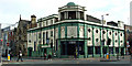
The Grosvenor Picture Palace
Viewed across Oxford Road from Cavendish Street.
See also Image
Image: © Thomas Nugent
Taken: 10 Nov 2014
0.02 miles
7

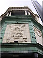
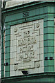
The Grosvenor Picture Palace: Name Frieze
Detail on the former Grosvenor Picture Palace Image
Image: © Gerald England
Taken: 13 May 2017
0.02 miles
8
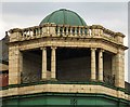
The Grosvenor Picture Palace: Pavilion and Dome
Detail on the former Grosvenor Picture Palace Image Above the corner is a 3-bay open-fronted pavilion with coupled Ionic columns, geometrical metal railings, cornice, balustraded parapet and domed roof.
Image: © Gerald England
Taken: 13 May 2017
0.02 miles
9

Entering Manchester on Upper Brook Street, 1966
View NW, towards the City centre. According to Keith Potter and Gerald England I was heading towards the then-pioneering 'tidal flow' system had been recently introduced at the junction with Grosvenor Street about 500 yards ahead. I was at about Brunswick Street and was passing on the left the site of the Manchester University buildings since erected there.
Image: © Ben Brooksbank
Taken: 27 Jul 1966
0.02 miles
10
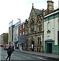
The Deaf & Dumb Institute
On Grosvenor Street, off Oxford Road. Now a music venue http://www.thedeafinstitute.co.uk/ .
Image: © Thomas Nugent
Taken: 10 Nov 2014
0.02 miles