IMAGES TAKEN NEAR TO
Oxford Road, MANCHESTER, M1 7DY
Introduction
This page details the photographs taken nearby to Oxford Road, M1 7DY by members of the Geograph project.
The Geograph project started in 2005 with the aim of publishing, organising and preserving representative images for every square kilometre of Great Britain, Ireland and the Isle of Man.

There are currently over 7.5m images from over14,400 individuals and you can help contribute to the project by visiting https://www.geograph.org.uk
Image Map
Images are licensed for reuse under creativecommons.org/licenses/by-sa/2.0
Notes
- Clicking on the map will re-center to the selected point.
- The higher the marker number, the further away the image location is from the centre of the postcode.
Image Listing (318 Images Found)
Images are licensed for reuse under creativecommons.org/licenses/by-sa/2.0
Image
Details
Distance
1
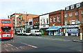
Oxford Road
Opposite All Saints Park.
Image: © Thomas Nugent
Taken: 10 Nov 2014
0.01 miles
2
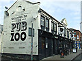
Pub Zoo
Two pubs on Grosvenor Street http://www.pubzoomanchester.co.uk/ .
Image: © Thomas Nugent
Taken: 10 Nov 2014
0.02 miles
3
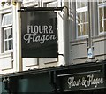
Sign of the Flour and Flagon
Sign for the Flour and Flagon Image
Image: © Gerald England
Taken: 11 Nov 2017
0.02 miles
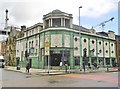
4
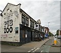
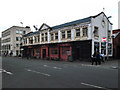
The Pub/Zoo
Located at 126 Grosvenor Street it was formerly known simply as "The Pub" Image In recent years it became two pubs with the premises on Sidney Street being known as "The Zoo".
Image
Since this photograph was taken "The Pub" has become "The Flour and Flagon" https://www.flourandflagon.co.uk/manchester and "The Zoo" has become "The Bread Shed" https://www.bread-shed.co.uk/manchester a theme that is based on the site's history as Duncan & Foster's bakery back in the 1900s https://confidentials.com/manchester/manchester-bar-former-pub-zoo-venue-to-become-bakery-inspired-bar-the-bread-shed
Image: © Gerald England
Taken: 13 May 2017
0.02 miles
5
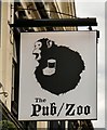
Sign of The Pub/Zoo
Sign for The Pub/Zoo Image
Image: © Gerald England
Taken: 13 May 2017
0.02 miles
6
Manchester, Grosvenor Picture Palace
Former cinema on Oxford Road, now The Footage Bar. Dating from 1912, Grade II listed by Historic England: https://historicengland.org.uk/listing/the-list/list-entry/1218431
Image: © Mike Faherty
Taken: 7 Feb 2019
0.02 miles
7
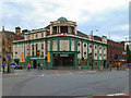
The Grosvenor Picture Palace ("Footage")
Former Cinema at the corner of Oxford Road and Grosvenor Street. The Grade II listed building first opened in May 1915 and thrived until the 1960s, closing in May 1968. It was a bingo hall for a while and is now trading as a bar under the name of "Footage".
Image: © David Dixon
Taken: 13 Jul 2010
0.02 miles
8
Oxford Road - All Saints
All Saints Park is on the right hand side. Ahead is the All Saints Building of Manchester Metropolitan University.
Image: © David Dixon
Taken: 13 Jul 2010
0.02 miles
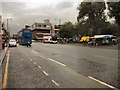
10
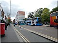
Buses on Oxford Road
The #263 was on its way to Altrincham but most will be going to Piccadilly. The area is thronged with students attending what is now known as Manchester Metropolitan University. Oxford Road is a section of the B5117.
Image: © Gerald England
Taken: 11 Oct 2022
0.02 miles