IMAGES TAKEN NEAR TO
Oxford Road, MANCHESTER, M1 7DU
Introduction
This page details the photographs taken nearby to Oxford Road, M1 7DU by members of the Geograph project.
The Geograph project started in 2005 with the aim of publishing, organising and preserving representative images for every square kilometre of Great Britain, Ireland and the Isle of Man.

There are currently over 7.5m images from over14,400 individuals and you can help contribute to the project by visiting https://www.geograph.org.uk
Image Map
Images are licensed for reuse under creativecommons.org/licenses/by-sa/2.0
Notes
- Clicking on the map will re-center to the selected point.
- The higher the marker number, the further away the image location is from the centre of the postcode.
Image Listing (395 Images Found)
Images are licensed for reuse under creativecommons.org/licenses/by-sa/2.0
Image
Details
Distance
1
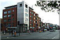
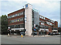
Oxford Road
Sidney Street is to the left of the building.
Image: © Thomas Nugent
Taken: 10 Nov 2014
0.02 miles
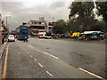
2
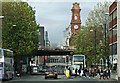
Oxford Road
Looking towards the Mancunian Way flyover from Cavendish Street.
Image: © Thomas Nugent
Taken: 10 Nov 2014
0.02 miles
3
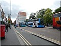
Buses on Oxford Road
The #263 was on its way to Altrincham but most will be going to Piccadilly. The area is thronged with students attending what is now known as Manchester Metropolitan University. Oxford Road is a section of the B5117.
Image: © Gerald England
Taken: 11 Oct 2022
0.02 miles
4
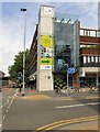
Corner of Oxford Road and Sidney Street
The building on the corner is occupied by the offices of the Estate and Facilities department of Manchester Metropolitan University. On the wall is a blue plaque commemorating Thomas Wright.
Image: © Gerald England
Taken: 15 Jun 2018
0.02 miles
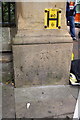
5

Hydrant sign and Blue Plaque (Thomas Wright)
On the wall of the offices of the Estate and Facilities department of Manchester Metropolitan University on Sidney Street Image is a blue plaque commemorating Thomas Wright next to a fire hydrant sign.
The inscription reads:
THOMAS WRIGHT
1789-1876
"THE PRISONERS' FRIEND"
BORN IN MANCHESTER AND LIVED IN
SIDNEY STREET. DEDICATED HIS LIFE TO
THE RELIEF OF HUMAN SUFFERING
AND IN PARTICULAR TO THE POOR AND
NEEDY OF THIS CITY.
A full account of his life can be found in the Rusholme and Victoria Park Archive http://rusholmearchive.org/thomas-wright-the-prisoners-friend
Image: © Gerald England
Taken: 15 Jun 2018
0.02 miles
6
Benchmark on wall pier, Oxford Road
Ordnance Survey cut mark benchmark described on the Bench Mark Database at http://www.bench-marks.org.uk/bm60848
Image: © Roger Templeman
Taken: 22 Sep 2014
0.02 miles
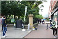
7
Oxford Road - All Saints
All Saints Park is on the right hand side. Ahead is the All Saints Building of Manchester Metropolitan University.
Image: © David Dixon
Taken: 13 Jul 2010
0.03 miles
8
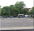
Salads Subs & Spuds
Looking across Oxford Road at the mobile food bar outside Grosvenor Square. The area is thronged with students attending what is now known as Manchester Metropolitan University. This area is known as All Saints.
Available on Oxford Road are bicycles for hire as part of the Bee Network https://beeactive.tfgm.com/cycle-hire/ The bikes are available on a Pay As You Ride (PAYR) basis. Pedal bikes cost 50p to unlock and 5p per minute to ride. E-bikes cost £1 to unlock and 10p per minute to ride.
Image: © Gerald England
Taken: 11 Oct 2022
0.03 miles
9
Student text books for sale, Oxford Road
Also promotion for 5/6-a-side football. There is an OS benchmark Image below a hydrant sign on the corner wall pier
Image: © Roger Templeman
Taken: 22 Sep 2014
0.03 miles
10
MMU Students' Union Building
The Met, 99 Oxford Road. Students' Union building of Manchester Metropolitan University.
http://en.wikipedia.org/wiki/MMUnion Wikipedia article
Image: © David Dixon
Taken: 13 Jul 2010
0.03 miles