IMAGES TAKEN NEAR TO
Samuel Ogden Street, MANCHESTER, M1 7AZ
Introduction
This page details the photographs taken nearby to Samuel Ogden Street, M1 7AZ by members of the Geograph project.
The Geograph project started in 2005 with the aim of publishing, organising and preserving representative images for every square kilometre of Great Britain, Ireland and the Isle of Man.

There are currently over 7.5m images from over14,400 individuals and you can help contribute to the project by visiting https://www.geograph.org.uk
Image Map
Images are licensed for reuse under creativecommons.org/licenses/by-sa/2.0
Notes
- Clicking on the map will re-center to the selected point.
- The higher the marker number, the further away the image location is from the centre of the postcode.
Image Listing (1156 Images Found)
Images are licensed for reuse under creativecommons.org/licenses/by-sa/2.0
Image
Details
Distance
1
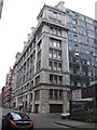
Orient House - Granby Row
This Grade II listed steel framed shipping or packing warehouse was built in 1914 to a design by G.H.Goldsmith. Now converted to apartments in the university quarter.
Image: © John M
Taken: 8 Nov 2011
0.01 miles
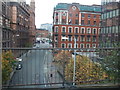
4
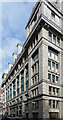
Orient House, Granby Row, Manchester
Imposing (and hard to photograph) former warehouse clad in white faience. The main front has plenty of Classical decoration, including Ionic columns, but underneath is a steel frame, apparent from the glass curtain-walling of the other elevations. Built c1914 to the designs of G.H. Goldsmith. Grade II listed.
It is now flats.
Image: © Stephen Richards
Taken: 22 Jun 2011
0.02 miles
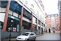
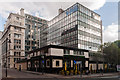
5
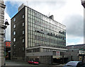
Salisbury House, Granby Row, Manchester
Empty 1960s/1970s office block with integrated pub (right, closed down).
Image: © Stephen Richards
Taken: 22 Jun 2011
0.02 miles
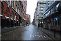
7
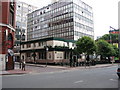
The Garratt
Public House on the junction of Granby Row with Princess Street, Manchester. The electrified railway line can just be seen, right middle ground of picture.
Image: © David Newton
Taken: 12 Jun 2009
0.03 miles
8
The Garratt
The Garratt public house on the corner of Granby Row and Princess Street.
Image: © Peter McDermott
Taken: 28 Sep 2014
0.03 miles
9
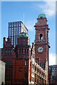
Kimpton Clocktower Hotel, Manchester
This grand building on Oxford Street was formerly the offices of the Refuge Assurance Company. It dates from 1891 when it was designed by Alfred Waterhouse but was significantly extended in 1910 and again in 1932. Refuge vacated it in 1987, moving to new purpose-built offices in Wilmslow, and the name has not survived, the company having since been absorbed into the Royal London Group. The building itself remained vacant for nearly a decade before being converted into a hotel opening as the Palace Hotel in 1996. After several changes of name and ownership, the Kimpton Clocktower name was adopted in 2020 as part of the InterContinental Hotels Group.
Image: © Stephen McKay
Taken: 30 Dec 2024
0.03 miles