IMAGES TAKEN NEAR TO
Tenax Road, MANCHESTER, M17 1WT
Introduction
This page details the photographs taken nearby to Tenax Road, M17 1WT by members of the Geograph project.
The Geograph project started in 2005 with the aim of publishing, organising and preserving representative images for every square kilometre of Great Britain, Ireland and the Isle of Man.

There are currently over 7.5m images from over14,400 individuals and you can help contribute to the project by visiting https://www.geograph.org.uk
Image Map
Images are licensed for reuse under creativecommons.org/licenses/by-sa/2.0
Notes
- Clicking on the map will re-center to the selected point.
- The higher the marker number, the further away the image location is from the centre of the postcode.
Image Listing (15 Images Found)
Images are licensed for reuse under creativecommons.org/licenses/by-sa/2.0
Image
Details
Distance
1
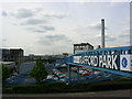
Trafford Park, Manchester
The World's first planned industrial estate and, in its heyday, Europe's biggest. SJ785972.
Image: © Keith Williamson
Taken: 11 May 2005
0.05 miles
2
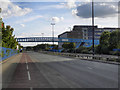
Bridge over Tenax Road
Footbridge over Tenax Road, Trafford Park.
Image: © David Dixon
Taken: 4 Sep 2011
0.06 miles
3
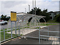
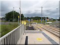
Cycle Racks at Parkway Tram Stop
With the exception of folding bikes, bicycles are not allowed on Metrolink trams. Cycle racks have been provided at most of the larger stops on the network. Parkway is the fourth tram stop on the Trafford Park Line after it diverges from the Eccles/MediaCityUK line at Pomona. The stop is on the green space between the two sides of Village Way, next to the Parkway Circle. It has been proposed that a park and ride facility will be provided nearby.
Image: © David Dixon
Taken: 2 Jul 2020
0.15 miles
5
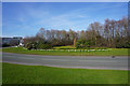
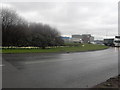
Parkway Circle
A green enclave in the centre of Trafford Park. The daffodils have recently come out, but they are well behind much of the country.
Image: © Bill Boaden
Taken: 6 Apr 2015
0.16 miles
6
Parkway Tram Stop
On the recently opened line to intu-Trafford Centre.
Image: © Gerald England
Taken: 7 Aug 2020
0.16 miles
7
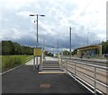
Trafford Park, Parkway Metrolink Stop
Parkway is the fourth tram stop on the Trafford Park Line after it leaves the Eccles/MediaCityUK line at Pomona. The stop is on the green space between the two sides of Village Way, next to the Parkway Circle. It has been proposed that a park and ride facility will be provided nearby.
Image: © David Dixon
Taken: 2 Jul 2020
0.17 miles
8
Parkway Tram Stop
On the newly opened line to the intu-Trafford Centre.
Image: © Gerald England
Taken: 7 Aug 2020
0.17 miles
9
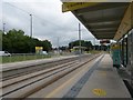
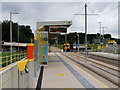
Parkway Tram stop
A stop on the Metrolink extension to the Trafford Centre which opened during the coronavirus pandemic lockdown. The platforms have circles to help passengers maintain social distancing whilst waiting.
Image: © Gerald England
Taken: 7 Aug 2020
0.17 miles
10
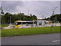
Metrolink Tram at Parkway
Metrolink Bombardier tram number 3068 waiting at Parkway tram stop on the journey to Cornbrook from the Trafford Centre. Parkway is the fourth tram stop on the Trafford Park Line, after it diverges from the Eccles/MediaCityUK line at Pomona. The stop is on the green space between the two sides of Village Way, next to the Parkway Circle. It has been proposed that a park and ride facility will be provided nearby.
Image: © David Dixon
Taken: 2 Jul 2020
0.18 miles