IMAGES TAKEN NEAR TO
Second Avenue, MANCHESTER, M17 1DZ
Introduction
This page details the photographs taken nearby to Second Avenue, M17 1DZ by members of the Geograph project.
The Geograph project started in 2005 with the aim of publishing, organising and preserving representative images for every square kilometre of Great Britain, Ireland and the Isle of Man.

There are currently over 7.5m images from over14,400 individuals and you can help contribute to the project by visiting https://www.geograph.org.uk
Image Map
Images are licensed for reuse under creativecommons.org/licenses/by-sa/2.0
Notes
- Clicking on the map will re-center to the selected point.
- The higher the marker number, the further away the image location is from the centre of the postcode.
Image Listing (80 Images Found)
Images are licensed for reuse under creativecommons.org/licenses/by-sa/2.0
Image
Details
Distance
1
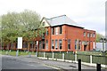
The Schoolhouse, Trafford Village
Built in 1914 as the primary school for Trafford Village, a role that ceased with the disappearance of residential properties in the area. It has been converted to office accommodation. The architecture is remarkably modern for the period.
Image: © Alan Murray-Rust
Taken: 12 May 2015
0.01 miles
2
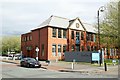
The Schoolhouse, Trafford Village
Built in 1914 as the primary school for Trafford Village, a role that ceased with the disappearance of residential properties in the area. It has been converted to office accommodation. The architecture is remarkably modern for the period.
Image: © Alan Murray-Rust
Taken: 12 May 2015
0.02 miles
3
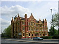
Trafford Park Hotel, Trafford Park, Manchester
Following the construction of the Manchester Ship Canal in 1895, Trafford Park, the ancestral home of the de Trafford family since medieval times, was transformed into the World's first, planned, industrial estate. In among all the great factories that formed the industrial estate a "workers" village was built along American lines of a gridlike pattern of "Avenues" and "Streets". This hotel was opened for visitors in 1902, on the corner of Third Avenue and a road now known as Village Way.
Image: © Keith Williamson
Taken: 11 May 2005
0.03 miles
4

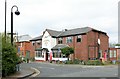
Trafford Park - Third Avenue, looking north
Image: © Peter Whatley
Taken: 22 Jan 2009
0.03 miles
5
The Village Inn, Trafford Village
This was built as a British Legion club, but has survived as a local pub for the industrial estate.
Image: © Alan Murray-Rust
Taken: 12 May 2015
0.04 miles
6
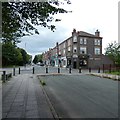
Corner of Third and Eleventh
The corner of Third Avenue and Eleventh Street lies at what was the heart of Trafford Park Estate. The old terraced houses that once housed the workers have long been demolished and replaced by modern business units. However here a range of shops including several kinds of eatery still serve workers on the estate.
Image: © Gerald England
Taken: 7 Aug 2020
0.10 miles
7
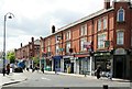
Third Avenue shops, Trafford Village
The shops, church and Village Inn pub are the only surviving functional elements of the original Trafford Village, the former residential area within the Trafford Park Estate.
At the height of the estate, there would be 30 or so trams, later buses, lined up in this street ready to take workers back to Manchester and Salford.
Image: © Alan Murray-Rust
Taken: 12 May 2015
0.10 miles
8
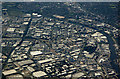
Village and Trafford Park from the air
The Manchester Ship Canal can be seen to the top and right (where Mode Wheel Locks are visible). The Bridgewater Canal is on the left. The large roundabout near the centre is Parkway Circle, Village Circle roundabout is to the lower right.
Image: © Thomas Nugent
Taken: 17 Jul 2017
0.11 miles
9
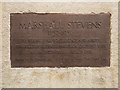
Marshall Stevens Memorial Plaque
Bronze plaque on Image It is inscribed:
Marshall Stevens
1852–1936
To whose foresight, energy and ability
the successful development of Trafford Park
as an industrial area is due
Image: © David Dixon
Taken: 14 Sep 2014
0.12 miles
10
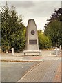
Marshall Stevens Memorial, Trafford Park Village
The memorial to Marshall Stevens, who is credited with being a prime mover in the creation of the Trafford Park Industrial Estate.
Marshall Stevens (1852 – 1936) was a property developer whose work with Daniel Adamson and others led to the construction of the Manchester Ship Canal, completed in 1894. In 1897, Stevens become general manager of Trafford Park Estates, a company set up to develop Trafford Park, the ancestral home of the de Trafford family, into what became the first and largest planned industrial estate in the world. He also served as Conservative Member of Parliament for Eccles from 1918 to 1922.
After Stevens died and was buried in St Catherine Church at Barton-upon-Irwell, shareholders in Trafford Park Estates subscribed to pay for a memorial. A 22-ton block of Welsh granite with a bronze portrait medallion and inscription was designed and made by Ashton upon Mersey sculptor, Arthur Sherwood Edwards. It was unveiled at the junction of Trafford Park Road and Ashburton Road in October 1937.
In 1993, the memorial was relocated to Wharfside Promenade with the introduction of a new road layout but as this site became part of Imperial War Museum North, the memorial was put into temporary storage when construction work began on the museum. It is now in Trafford Park Village at the junction of Third Avenue and Eleventh Street, opposite the St Antony Centre.
The memorial is inscribed:
Marshall Stevens
1852–1936
To whose foresight, energy and ability
the successful development of Trafford Park
as an industrial area is due
Image]
Abridged from http://en.wikipedia.org/wiki/Marshall_Stevens (Wikipedia)
Image: © David Dixon
Taken: 14 Sep 2014
0.12 miles