IMAGES TAKEN NEAR TO
Churchill Way, MANCHESTER, M17 1BS
Introduction
This page details the photographs taken nearby to Churchill Way, M17 1BS by members of the Geograph project.
The Geograph project started in 2005 with the aim of publishing, organising and preserving representative images for every square kilometre of Great Britain, Ireland and the Isle of Man.

There are currently over 7.5m images from over14,400 individuals and you can help contribute to the project by visiting https://www.geograph.org.uk
Image Map
Images are licensed for reuse under creativecommons.org/licenses/by-sa/2.0
Notes
- Clicking on the map will re-center to the selected point.
- The higher the marker number, the further away the image location is from the centre of the postcode.
Image Listing (37 Images Found)
Images are licensed for reuse under creativecommons.org/licenses/by-sa/2.0
Image
Details
Distance
1
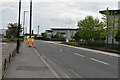
Trafford Wharf Road & Fuel Depot
The extensive fuel depot is on the right.
Image: © Peter Whatley
Taken: 22 Jan 2009
0.08 miles
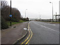
3
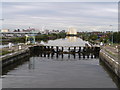
Inside Mode Wheel Lock
This is the first lock on Manchester Ship Canal, travelling towards Liverpool.
Image: © John Readman
Taken: 2 Oct 2005
0.10 miles
4
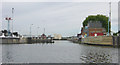
Mode Wheel Lock, Manchester Ship Canal
Mode Wheel locks are the last set of locks before the Manchester Ship Canal reached Salford and Manchester Docks.
Image: © Martin Clark
Taken: Unknown
0.10 miles
6
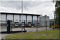
Trafford, dairy
Robert Wiseman's dairy and distribution depot. http://www.wiseman-dairies.co.uk/our-company/wiseman-across-the-uk/
Image: © Mike Faherty
Taken: 18 Sep 2011
0.14 miles
7
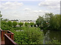
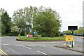
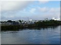
The Lake, Trafford Ecology Park, Trafford Park, Manchester
Trafford Ecology Park is an 11 acre site centred on the former boating lake of the Trafford Estate, the ancestral home of the de Trafford family.
From the latter part of the 19th Century (after the opening of the Manchester Ship Canal) the estate grew into Europe's largest industrial estate.
The lake was used for leisure until the 1930's, then was almost filled in by tipping operations that went on until the 1970's. In 1973 Esso secured the site and started recovery and restoration work. It is now owned and managed by Groundwork, a local environmental regeneration organisation. SJ792975.
Image: © Keith Williamson
Taken: 11 May 2005
0.14 miles