IMAGES TAKEN NEAR TO
Sixth Street, MANCHESTER, M17 1BG
Introduction
This page details the photographs taken nearby to Sixth Street, M17 1BG by members of the Geograph project.
The Geograph project started in 2005 with the aim of publishing, organising and preserving representative images for every square kilometre of Great Britain, Ireland and the Isle of Man.

There are currently over 7.5m images from over14,400 individuals and you can help contribute to the project by visiting https://www.geograph.org.uk
Image Map
Images are licensed for reuse under creativecommons.org/licenses/by-sa/2.0
Notes
- Clicking on the map will re-center to the selected point.
- The higher the marker number, the further away the image location is from the centre of the postcode.
Image Listing (115 Images Found)
Images are licensed for reuse under creativecommons.org/licenses/by-sa/2.0
Image
Details
Distance
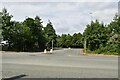
1
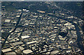
Village and Trafford Park from the air
The Manchester Ship Canal can be seen to the top and right (where Mode Wheel Locks are visible). The Bridgewater Canal is on the left. The large roundabout near the centre is Parkway Circle, Village Circle roundabout is to the lower right.
Image: © Thomas Nugent
Taken: 17 Jul 2017
0.04 miles
2
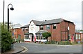
The Village Inn, Trafford Village
This was built as a British Legion club, but has survived as a local pub for the industrial estate.
Image: © Alan Murray-Rust
Taken: 12 May 2015
0.08 miles
3
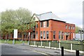
The Schoolhouse, Trafford Village
Built in 1914 as the primary school for Trafford Village, a role that ceased with the disappearance of residential properties in the area. It has been converted to office accommodation. The architecture is remarkably modern for the period.
Image: © Alan Murray-Rust
Taken: 12 May 2015
0.08 miles
5
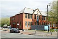
The Schoolhouse, Trafford Village
Built in 1914 as the primary school for Trafford Village, a role that ceased with the disappearance of residential properties in the area. It has been converted to office accommodation. The architecture is remarkably modern for the period.
Image: © Alan Murray-Rust
Taken: 12 May 2015
0.09 miles
7
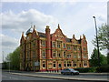
Trafford Park Hotel, Trafford Park, Manchester
Following the construction of the Manchester Ship Canal in 1895, Trafford Park, the ancestral home of the de Trafford family since medieval times, was transformed into the World's first, planned, industrial estate. In among all the great factories that formed the industrial estate a "workers" village was built along American lines of a gridlike pattern of "Avenues" and "Streets". This hotel was opened for visitors in 1902, on the corner of Third Avenue and a road now known as Village Way.
Image: © Keith Williamson
Taken: 11 May 2005
0.10 miles
8
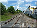
Some more of the disused railway in Trafford Park
Image: © Alexander P Kapp
Taken: 14 Jun 2012
0.10 miles
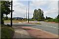
9

Trafford Park - Third Avenue, looking north
Image: © Peter Whatley
Taken: 22 Jan 2009
0.11 miles