IMAGES TAKEN NEAR TO
Harter Street, MANCHESTER, M1 6HP
Introduction
This page details the photographs taken nearby to Harter Street, M1 6HP by members of the Geograph project.
The Geograph project started in 2005 with the aim of publishing, organising and preserving representative images for every square kilometre of Great Britain, Ireland and the Isle of Man.

There are currently over 7.5m images from over14,400 individuals and you can help contribute to the project by visiting https://www.geograph.org.uk
Image Map
Images are licensed for reuse under creativecommons.org/licenses/by-sa/2.0
Notes
- Clicking on the map will re-center to the selected point.
- The higher the marker number, the further away the image location is from the centre of the postcode.
Image Listing (1967 Images Found)
Images are licensed for reuse under creativecommons.org/licenses/by-sa/2.0
Image
Details
Distance
1
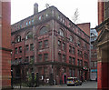
2 Harter Street, Manchester
Built as a paper warehouse in the late C19th. Of plum-red brick with impressive arcades in the upper storeys and pilasters adorned with swags. Grade II listed.
For how long has it been empty? A small wood is developing above the cornice.
Image: © Stephen Richards
Taken: 22 Jun 2011
0.02 miles
2
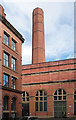
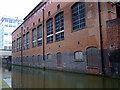
Electricity station, Winser Street, Manchester
Built 1901, with arched windows and prominent octagonal chimney. Grade II listed.
It was apparently one of the earliest combined heat and power stations in the country. I believe that in some form or another it still provides power.
Image: © Stephen Richards
Taken: 22 Jun 2011
0.03 miles
3
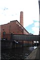
Former Power Station by the Rochdale Canal
Grade II listed. http://www.britishlistedbuildings.co.uk/en-458617-former-electricity-power-station-
Built in 1901.
Image: © N Chadwick
Taken: 28 Aug 2014
0.03 miles
4
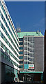
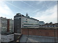
Linley House, Dickinson Street, Manchester
A 1960s/1970s office block with modish ceramic tiles, feature staircase, and an arresting mixture of green, white and black. It's T-shaped and continues behind.
Recently refurbished and awaiting new tenants.
Image: © Stephen Richards
Taken: 23 Jul 2011
0.04 miles
5

Linley House
Linley House, glass office block at the end of the road, was once the home to the North West Electricity Board. It built in 1963 by H. S. Fairhurst & Son. It stands on the site of the former Dickinson Road power station.
Image: © Bob Harvey
Taken: 11 Sep 2019
0.04 miles
6
Linley House
Built on the site of the Dickinson Road power station in 1963 by H. S. Fairhurst & Son., this was once the offices of the Northwest Electricity Board. The current owners, United Utilities, are their successor, and the building has also been home to Cable and Wireless Ltd.
Image: © Bob Harvey
Taken: 11 Apr 2017
0.04 miles
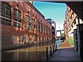
7
The Rochdale Canal
I wonder what has passed through those doors over the years?
Image: © Thomas Nugent
Taken: 28 Feb 2011
0.04 miles
8
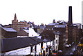
Bloom Street, Manchester
This is well in the Gay Village but my focal point was the truncated city centre chimney. This is on Bloom Street (Winser Street) Power Station. This had been built as an electrical power station but in more recent years had provided district heating. It was built in 1901 as a power station for lighting and tramways with reciprocating steam engines. The original Babcock & Wilcox boilers were replaced by oil-fired boilers in 1953.
District heating, especially combined as a CHP (combined heat and power) scheme is an excellent energy efficient concept that has yet to find much favour in the UK. The best schemes make use of in excess of 90% of the energy in the fuel. By contrast your big old coal burning power station is around 37-40% efficient, many combined cycle stations can do around 50% and the very best have cracked 60%. On the other hand a steam locomotive was around 6% (all figures approximate).
Image: © Chris Allen
Taken: 21 Nov 1992
0.04 miles
9
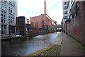
Rochdale Canal and former Power Station
Grade II listed. http://www.britishlistedbuildings.co.uk/en-458617-former-electricity-power-station-
Image: © N Chadwick
Taken: 28 Aug 2014
0.04 miles
10
Former Electricity Power Station
The Rochdale canal view of a listed building, the former Winser Street electric power station, often known as Bloom Street power station. It was built by the city council and was the second electric power station to be built to supply the city and nearby suburbs. The first was adjacent to it in Dickinson Street.
The base of the matching redbrick boiler chimney can just be seen above the centre of the roof. It started to supply power (direct current, DC not AC, alternating current as supplied today) in 1901 and the new municipal electric tram services were big power consumers.
It looks designed so that coal could be directly off-loaded from barges into the power station bunkers. The bridge crossing the canal in the distance carries Princess Street. Above the photographer is an access bridge to the power station.
Image: © Glyn Baker
Taken: 15 Jul 2006
0.04 miles