IMAGES TAKEN NEAR TO
Seymour Grove, MANCHESTER, M16 9QS
Introduction
This page details the photographs taken nearby to Seymour Grove, M16 9QS by members of the Geograph project.
The Geograph project started in 2005 with the aim of publishing, organising and preserving representative images for every square kilometre of Great Britain, Ireland and the Isle of Man.

There are currently over 7.5m images from over14,400 individuals and you can help contribute to the project by visiting https://www.geograph.org.uk
Image Map
Images are licensed for reuse under creativecommons.org/licenses/by-sa/2.0
Notes
- Clicking on the map will re-center to the selected point.
- The higher the marker number, the further away the image location is from the centre of the postcode.
Image Listing (16 Images Found)
Images are licensed for reuse under creativecommons.org/licenses/by-sa/2.0
Image
Details
Distance
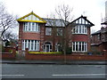
3
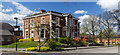
Stretford Memorial Hospital
Stretford Memorial Hospital on Seymour Grove.
Image: © Peter McDermott
Taken: 19 Apr 2015
0.09 miles
4
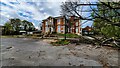
Stretford Memorial Hospital
Basford House, what was Stretford Memorial Hospital on Seymour Grove.
See also Image
Image: © Peter McDermott
Taken: 2 May 2021
0.09 miles
8
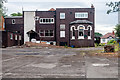
Throstle's Nest
The rear of the disused Throstle's Nest public house.
Image: © Peter McDermott
Taken: 19 Jul 2014
0.17 miles