IMAGES TAKEN NEAR TO
Henrietta Street, MANCHESTER, M16 9PN
Introduction
This page details the photographs taken nearby to Henrietta Street, M16 9PN by members of the Geograph project.
The Geograph project started in 2005 with the aim of publishing, organising and preserving representative images for every square kilometre of Great Britain, Ireland and the Isle of Man.

There are currently over 7.5m images from over14,400 individuals and you can help contribute to the project by visiting https://www.geograph.org.uk
Image Map
Images are licensed for reuse under creativecommons.org/licenses/by-sa/2.0
Notes
- Clicking on the map will re-center to the selected point.
- The higher the marker number, the further away the image location is from the centre of the postcode.
Image Listing (11 Images Found)
Images are licensed for reuse under creativecommons.org/licenses/by-sa/2.0
Image
Details
Distance
1
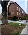
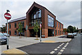
Limelight Community Hub, Old Trafford
Limelight is a new community health and well-being hub based in the heart of the Old Trafford area. In 2013, Trafford Housing Trust gained funding to build 80 Extra Care apartments in the Old Trafford area. Working in collaboration with Trafford Council, the Trust took the opportunity to redevelop the Old Community Centre also known as The Library on Shrewsbury Street.
The new Limelight development was designed in two phases; the first phase was to demolish the community centre and to re-site St Brides Church to an empty plot of land on St Brides Way. The Church was completed in 2016 and was officially opened on Mother’s Day 2016.
The second phase of the Limelight development includes 81 Extra Care apartments for older and vulnerable people and a day nursery, pharmacy, hair and beauty hub, café, library, meeting room facilities for hire and healthcare facilities.
Image: © David Dixon
Taken: 14 Aug 2018
0.19 miles
2
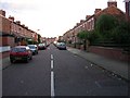
Old Trafford
Fulford Street, Old Trafford from its junction with Northumberland Road. A typical residential street of the area. SJ822958
Image: © Keith Williamson
Taken: 1 Sep 2005
0.19 miles
3
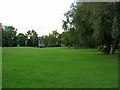
Seymour Park, Old Trafford
Looking NW across the park. SJ821959
Image: © Keith Williamson
Taken: 1 Sep 2005
0.19 miles
4

Trafford, Buddhist temple
Once technical institute and library, this building on Stretford Road now houses the Fo Guang Shan Buddhist Temple. Chinese readers will find this link useful: http://www.blia.org/
Image: © Mike Faherty
Taken: 24 Jan 2009
0.20 miles
5
Trafford, Bailey Italia Caf
Slightly bizarre metal-fronted café on Stretford Road. Up metal spiral stairway to first floor; sit under parasols and camouflage netting (indoors). When you've finished, you can browse neighbouring camping equipment. http://www.baileyitalia.co.uk/
Image: © Mike Faherty
Taken: 24 Jan 2009
0.21 miles
6
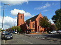
St Bride's Church, Old Trafford
The original St Bride’s church was founded in 1878. It has been re-sited to a new building opened in 2016 as part of the Limelight development (Image]).
Image: © David Dixon
Taken: 14 Aug 2018
0.21 miles
7
Trafford, St. John the Evangelist's
Parish church at the corner of Ayres Road and Lindum Avenue.
Image: © Mike Faherty
Taken: 17 Sep 2011
0.21 miles
8
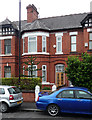
188 Ayres Road, Manchester
Representative of the housing in this area of Old Trafford. I snapped this one specifically because I lived in it in 1986/87 while studying at the University of Manchester. To be honest, I hardly recognise the place, but for £40 monthly rent what could one expect?
Image: © Stephen Richards
Taken: 25 Jun 2011
0.23 miles
9
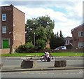
Delivery bike on Stretford Road
I don't know what he was trying to deliver. It looked as if there might be a problem with the wheel or tyre and he was trying to effect a repair.
Image: © Gerald England
Taken: 26 Aug 2017
0.24 miles
10
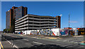
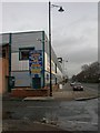
West Point
Multi-storey car park at West Point.
Image: © Peter McDermott
Taken: 13 Apr 2020
0.24 miles