IMAGES TAKEN NEAR TO
City Park Business Village, Brindley Road, MANCHESTER, M16 9FX
Introduction
This page details the photographs taken nearby to City Park Business Village, Brindley Road, M16 9FX by members of the Geograph project.
The Geograph project started in 2005 with the aim of publishing, organising and preserving representative images for every square kilometre of Great Britain, Ireland and the Isle of Man.

There are currently over 7.5m images from over14,400 individuals and you can help contribute to the project by visiting https://www.geograph.org.uk
Image Map
Images are licensed for reuse under creativecommons.org/licenses/by-sa/2.0
Notes
- Clicking on the map will re-center to the selected point.
- The higher the marker number, the further away the image location is from the centre of the postcode.
Image Listing (155 Images Found)
Images are licensed for reuse under creativecommons.org/licenses/by-sa/2.0
Image
Details
Distance
1
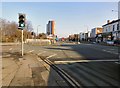
A5014, Old Trafford
We are standing at the end of Talbot Road, the A5014, which continues ahead as Chester Road. Chester Road continues on the left as the A5067. The skyscraper ahead is West Point.
Image: © Gerald England
Taken: 13 Feb 2017
0.08 miles
3
Chester Road, Old Trafford
The Old Trafford branch of Martins Bank at 555 Chester Road was opened in 1899 as the Lancashire and Yorkshire Bank Ltd. It became a Martins Bank in 1928 and a branch of Barclays in 1969. It was closed in June 1992 after "one too many armed hold-ups" http://www.martinsbank.co.uk/11-61-60%20Manchester%20Old%20Trafford.htm Originally the bank had a second entrance on Talbot Road but that was closed in the 1980s as it was being used as a thoroughfare.
Image: © Gerald England
Taken: 13 Feb 2017
0.09 miles
5
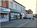
621 Caf? & Bar
621 Stretford Road, Old Trafford is the 621 Cafe and Bar. On the right is Sabz Solicitors.
Image: © Gerald England
Taken: 13 Feb 2017
0.09 miles
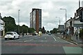
6
Old Trafford, Talbot Road
A5104 towards the city centre.
Image: © David Dixon
Taken: 14 Aug 2020
0.10 miles
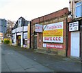
7
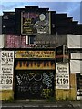
Abandoned fireplace shop
Abandoned derelict shop, Old Trafford.
Image: © Paul Foster
Taken: 11 May 2023
0.10 miles
8
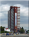
West Point, Chester Road, Stretford
One of a cluster of substantial post-war office blocks in the Old Trafford area, perhaps part of a drive to attract business in the face of ailing industry. There is a local station, and the nearby A56 runs, in one direction, to what was the Stretford by-pass or M62 when it opened in 1960 (now the M60), and, in the other direction, to central Manchester.
West Point, which will be a modern moniker, stands at the point at which Chester and Stretford Roads diverge.
Image: © Stephen Richards
Taken: 25 Jul 2011
0.10 miles
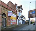
9
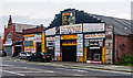
Tommy's
Tommy's "World Famous House of Fires" on Talbot Road.
Image: © Peter McDermott
Taken: 19 Jul 2014
0.10 miles
10
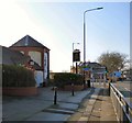
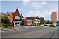
The Tollgate
A Marstons pub on the corner of Talbot Road and Seymour Road. In the background behind the signs Image is the former Trafford Bar station now a tram stop.
Image: © Gerald England
Taken: 13 Feb 2017
0.11 miles