IMAGES TAKEN NEAR TO
Seymour Close, MANCHESTER, M16 9DN
Introduction
This page details the photographs taken nearby to Seymour Close, M16 9DN by members of the Geograph project.
The Geograph project started in 2005 with the aim of publishing, organising and preserving representative images for every square kilometre of Great Britain, Ireland and the Isle of Man.

There are currently over 7.5m images from over14,400 individuals and you can help contribute to the project by visiting https://www.geograph.org.uk
Image Map
Images are licensed for reuse under creativecommons.org/licenses/by-sa/2.0
Notes
- Clicking on the map will re-center to the selected point.
- The higher the marker number, the further away the image location is from the centre of the postcode.
Image Listing (56 Images Found)
Images are licensed for reuse under creativecommons.org/licenses/by-sa/2.0
Image
Details
Distance
1
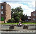
Delivery bike on Stretford Road
I don't know what he was trying to deliver. It looked as if there might be a problem with the wheel or tyre and he was trying to effect a repair.
Image: © Gerald England
Taken: 26 Aug 2017
0.03 miles
2
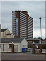
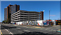
Westpoint
Not the American military academy, simply a multi-storey office block on Chester Road, Old Trafford.
Image: © Alan Murray-Rust
Taken: 14 Aug 2009
0.04 miles
3
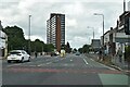
West Point, Chester Road, Stretford
One of a cluster of substantial post-war office blocks in the Old Trafford area, perhaps part of a drive to attract business in the face of ailing industry. There is a local station, and the nearby A56 runs, in one direction, to what was the Stretford by-pass or M62 when it opened in 1960 (now the M60), and, in the other direction, to central Manchester.
West Point, which will be a modern moniker, stands at the point at which Chester and Stretford Roads diverge.
Image: © Stephen Richards
Taken: 25 Jul 2011
0.05 miles
4
Westpoint, Trafford
Office block on Chester Road.
Image: © David Dixon
Taken: 16 Oct 2011
0.05 miles
5
West Point
Multi-storey car park at West Point.
Image: © Peter McDermott
Taken: 13 Apr 2020
0.06 miles
6
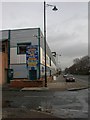
Trafford, Bailey Italia Caf
Slightly bizarre metal-fronted café on Stretford Road. Up metal spiral stairway to first floor; sit under parasols and camouflage netting (indoors). When you've finished, you can browse neighbouring camping equipment. http://www.baileyitalia.co.uk/
Image: © Mike Faherty
Taken: 24 Jan 2009
0.09 miles
7
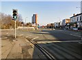
A5014, Old Trafford
We are standing at the end of Talbot Road, the A5014, which continues ahead as Chester Road. Chester Road continues on the left as the A5067. The skyscraper ahead is West Point.
Image: © Gerald England
Taken: 13 Feb 2017
0.14 miles
8
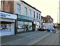
621 Caf? & Bar
621 Stretford Road, Old Trafford is the 621 Cafe and Bar. On the right is Sabz Solicitors.
Image: © Gerald England
Taken: 13 Feb 2017
0.15 miles
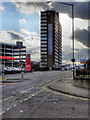
10
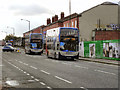
Buses on Chester Road
Two Stagecoach buses, on routes 255 and 256, make their way along Chester Road (A5104) en-route for Manchester city centre.
Image: © David Dixon
Taken: 16 Oct 2011
0.18 miles