IMAGES TAKEN NEAR TO
Holwood Drive, MANCHESTER, M16 8WS
Introduction
This page details the photographs taken nearby to Holwood Drive, M16 8WS by members of the Geograph project.
The Geograph project started in 2005 with the aim of publishing, organising and preserving representative images for every square kilometre of Great Britain, Ireland and the Isle of Man.

There are currently over 7.5m images from over14,400 individuals and you can help contribute to the project by visiting https://www.geograph.org.uk
Image Map
Images are licensed for reuse under creativecommons.org/licenses/by-sa/2.0
Notes
- Clicking on the map will re-center to the selected point.
- The higher the marker number, the further away the image location is from the centre of the postcode.
Image Listing (34 Images Found)
Images are licensed for reuse under creativecommons.org/licenses/by-sa/2.0
Image
Details
Distance
1
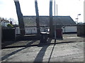
Whalley Range Cricket Club - Entrance
The pavilion at Whalley Range CC showing the iron work "Whalley Range Cricket & Tennis Club". The club run three teams in the Manchester & District Cricket Association.
Image: © BatAndBall
Taken: 25 Mar 2013
0.06 miles
2
Whalley Range Cricket Club - Pavilion
The iron work at the club says "Old Hulmeians Memorial Ground" displaying the historical links to William Hulme Grammar School. A recent historical project at the club discovered that the composer Frederick Delius played there in the 1880's.
Image: © BatAndBall
Taken: 25 Mar 2013
0.06 miles
3
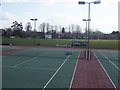
Whalley Range Cricket Club - Ground
Looking across the tennis courts at Whalley Range CC's Kingsbrook Road ground.
Image: © BatAndBall
Taken: 25 Mar 2013
0.08 miles
5
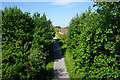
Cycle route on a former railway
The route runs from Chorlton right across South Manchester to where the line used to join the Trans-Pennine line at Fairfield. It is viewed here from Alexandra Road South.
Image: © Bill Boaden
Taken: 10 Jun 2015
0.08 miles
6
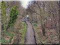
Cycleway
Cycleway along the course of the former railway line. Viewed from Alexandra Road South.
Image: © David Dixon
Taken: 7 Jan 2012
0.10 miles
7
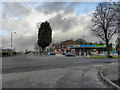
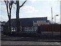
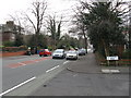
Mauldeth Road West
Filling station on the corner of Mauldeth Road West and Alexandra Road South
Image: © David Dixon
Taken: 7 Jan 2012
0.12 miles
8
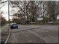
Entrance to Hough End Playing Fields
The Entrance to Hough End Clough and the Hough End Playing Fields on Mauldeth Road West, at Houghend Crescent.
Image: © David Dixon
Taken: 7 Jan 2012
0.14 miles
10
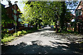
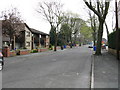
Woodlands Road
A private road in a residential area.
Image: © Bill Boaden
Taken: 10 Jun 2015
0.14 miles