IMAGES TAKEN NEAR TO
Manley Road, MANCHESTER, M16 8PN
Introduction
This page details the photographs taken nearby to Manley Road, M16 8PN by members of the Geograph project.
The Geograph project started in 2005 with the aim of publishing, organising and preserving representative images for every square kilometre of Great Britain, Ireland and the Isle of Man.

There are currently over 7.5m images from over14,400 individuals and you can help contribute to the project by visiting https://www.geograph.org.uk
Image Map
Images are licensed for reuse under creativecommons.org/licenses/by-sa/2.0
Notes
- Clicking on the map will re-center to the selected point.
- The higher the marker number, the further away the image location is from the centre of the postcode.
Image Listing (39 Images Found)
Images are licensed for reuse under creativecommons.org/licenses/by-sa/2.0
Image
Details
Distance
1
Church of the English Martyrs, Alexandra Road, Whalley Range
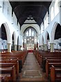
Interior of the church of the English Martyrs (RC)
Image: © Tom Jolliffe
Taken: 30 Sep 2016
0.04 miles
2
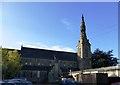
Church of the English Martyrs, Alexandra Road, Whalley Range
The late 19th century church seen from the car park.
Image: © Tom Jolliffe
Taken: 30 Sep 2016
0.07 miles
3
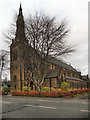
English Martyrs Parish Church
The Church of the English Martyrs, on Alexandra Road South in Whalley Range, was opened in 1896.
Image: © David Dixon
Taken: 7 Jan 2012
0.08 miles
4
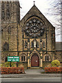
English Martyrs Catholic Church Door and Rose Window
The English Martyrs Church on Alexandra Road South in Whalley Range (see Image] for photograph including the spire) was built in 1896. the rose window, above the doorway, was presented to the parish in memory of Freda Waugh in 1919 and depicts the twelve fruits of the Holy Spirit.
http://www.empc.org.uk/pages/parish_church.html - English Martyrs Parish Centre
Image: © David Dixon
Taken: 7 Jan 2012
0.08 miles
5
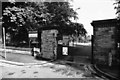
Alexandra Park entrance gates, Demesne Road, Whalley Range
The sign gives notice of an experimental cycle route through the park.
Image: © Tom Jolliffe
Taken: Unknown
0.09 miles
6
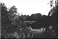
Alexandra Park Lake, Moss Side
The ornamental lake in Alexandra Park always had a population of ducks and swans. It is also used by fishing enthusiasts, who probably exercise some control over the potential excesses of deliquents.
Image: © Tom Jolliffe
Taken: Unknown
0.10 miles
8

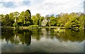
Alexandra Park Lake
Alexandra Park is a 60-acre park located between Princess Road, Claremont Road, Demesne Road and Alexandra Road South, in the Moss Side/Whalley Range districts of Manchester. It was opened in 1870. (http://www.manchester.gov.uk/info/200073/parks_and_open_spaces/188/alexandra_park/4 - Manchester City Council)
Image: © David Dixon
Taken: 7 Jan 2012
0.12 miles
9
Cenacle Convent grounds, Whalley Range, Manchester
The grounds of the Cenacle Convent as they were in 1982. The house in the picture was on the other side of Stanley Road. These grounds have now been used for a housing development. Also see Image] Image] Image] Image]
Image: © Tom Jolliffe
Taken: Unknown
0.13 miles
10
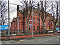
William Hulme's Grammar School Original Building
William Hulme, founder of the William Hulme Charity, lived 1631–1691 in Hulme Hall, Stockport. In 1881, the Trustees of his charity were empowered to build schools and WHGS was founded in Manchester in 1887.
The original part of the school was designed by A H Davies-Colley in 1886–1887 as a large, high building of red brick and yellow terracotta. Next to it is a hall built in 1910 in the same style.
http://en.wikipedia.org/wiki/William_Hulme's_Grammar_School - Wikipedia
Image: © David Dixon
Taken: 7 Jan 2012
0.13 miles