IMAGES TAKEN NEAR TO
Alphonsus Street, MANCHESTER, M16 7RA
Introduction
This page details the photographs taken nearby to Alphonsus Street, M16 7RA by members of the Geograph project.
The Geograph project started in 2005 with the aim of publishing, organising and preserving representative images for every square kilometre of Great Britain, Ireland and the Isle of Man.

There are currently over 7.5m images from over14,400 individuals and you can help contribute to the project by visiting https://www.geograph.org.uk
Image Map
Images are licensed for reuse under creativecommons.org/licenses/by-sa/2.0
Notes
- Clicking on the map will re-center to the selected point.
- The higher the marker number, the further away the image location is from the centre of the postcode.
Image Listing (20 Images Found)
Images are licensed for reuse under creativecommons.org/licenses/by-sa/2.0
Image
Details
Distance
1
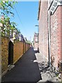
Whalley Range, ginnel
Between Milner Street and St. John's Road.
Image: © Mike Faherty
Taken: 12 Aug 2015
0.06 miles
2
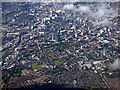
Manchester from the air
Looking over Hulme towards the city centre from above Northenden (4 miles south) from a Prague bound flight from Manchester. The A57(M) road marks the clear boundary between city and suburb.
Image: © Thomas Nugent
Taken: 6 Jul 2020
0.06 miles
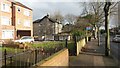
3
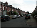
Whalley Range, Norton Street
Rows of Victorian terraced houses between streets arranged as a grid.
Image: © Mike Faherty
Taken: 29 Aug 2009
0.07 miles
5
Whalley Range, delivery office
Royal Mail's SW Delivery Office in Norton Street.
Image: © Mike Faherty
Taken: 29 Aug 2009
0.12 miles
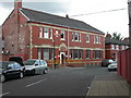
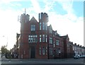
6
Post Office / Drill Hall
Currently a GPO Sorting Office but once the Drill Hall for 1, 2 and 3 East Lancashire Divisional Field Ambulances RAMC (HQ, A and B Sections)
Image: © Anthony Parkes
Taken: 30 Sep 2014
0.12 miles
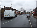
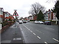
8
Morning sunlight on Upper Chorlton Road
Image: © David Martin
Taken: 16 Feb 2017
0.15 miles
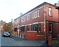
9
Army Cadet Centre - Stretford Detachment
Army Cadets, & Army Reserve are based here currently. In WW1 this was the Drill Hall for 1, 2 and 3 East Lancashire Divisional Field Ambulances RAMC (HQ, A and B Sections)
Image: © Anthony Parkes
Taken: 30 Sep 2014
0.16 miles
10

Army Reserve Centre - Stretford Detachment
Army Cadets & Army Reserve are currently based here. In WW1 this was the Drill Hall for 1, 2 and 3 East Lancashire Divisional Field Ambulances RAMC (HQ, A and B Sections)
Image: © Anthony Parkes
Taken: 30 Sep 2014
0.16 miles