IMAGES TAKEN NEAR TO
Elwick Close, MANCHESTER, M16 7LA
Introduction
This page details the photographs taken nearby to Elwick Close, M16 7LA by members of the Geograph project.
The Geograph project started in 2005 with the aim of publishing, organising and preserving representative images for every square kilometre of Great Britain, Ireland and the Isle of Man.

There are currently over 7.5m images from over14,400 individuals and you can help contribute to the project by visiting https://www.geograph.org.uk
Image Map
Images are licensed for reuse under creativecommons.org/licenses/by-sa/2.0
Notes
- Clicking on the map will re-center to the selected point.
- The higher the marker number, the further away the image location is from the centre of the postcode.
Image Listing (42 Images Found)
Images are licensed for reuse under creativecommons.org/licenses/by-sa/2.0
Image
Details
Distance
1
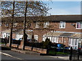
Houses on Yeovil Street in Moss Side
Houses on Yeovil Street on the Alexandra Park Estate in Moss Side, Manchester
Image: © Stephen Taylor
Taken: 14 Mar 2011
0.07 miles
2
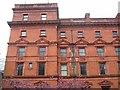
St. Bede's College and Prep School, Alexandra Road, Whalley Range
Image: © Paul Ashwin
Taken: 16 Apr 2005
0.09 miles
3

Grand steps and promenade at Alexandra Park
Alexandra Park is one of Manchester’s earliest and most intact Victorian Parks. In 1995 the park was listed Grade 2 on the English Heritage Register of Parks and Gardens.
The 60-acre site for the Park was bought by Manchester Corporation and laid out between 1868 and 1870. The design was the subject of an architectural competition which was won by Alexander Gordon Hennell of Chancery Lane, London.
Hennell’s winning design was ahead of its time, integrating the provision of traditional ornamental features and sporting facilities, something we take for granted in parks today.
The design exploited the flat and featureless site by creating a series of broad sweeping and curved footpaths, perfect for the Victorian fashion of promenading, whilst defining the oval activity areas.
In 2014 the park was sympathetically restored, reinstating and repairing the original features and adapting facilities to meet the demands of a modern park.
Image: © Ian Greig
Taken: 23 Apr 2015
0.11 miles
4
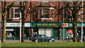
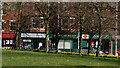
Shops and flats on Princess Road in Moss Side
Shops and flats on Princess Road in Moss Side, Manchester
Image: © Stephen Taylor
Taken: 14 Mar 2011
0.13 miles
5
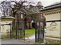
Alexandra Park, Claremont Road Gate and Chorlton Lodge
Alexandra Park is a 60-acre park located between Princess Road, Claremont Road, Demesne Road and Alexandra Road South, in the Moss Side/Whalley Range districts of Manchester. It was opened in 1870. The park contains Chorlton Lodge near to the Claremont Road Gate. Both the lodge and gateway are the work of Alfred Darbyshire.
(http://www.manchester.gov.uk/info/200073/parks_and_open_spaces/188/alexandra_park/4 - Manchester City Council)
Image: © David Dixon
Taken: 7 Jan 2012
0.13 miles
6
Shops on Princess Road in Moss Side
Shops on Princess Road in Moss Side, Manchester
Image: © Stephen Taylor
Taken: 14 Mar 2011
0.13 miles
7
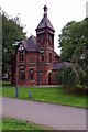
Chorlton Lodge
The survivor of two Park Keepers lodges for Alexandria park built in the 1860's. It is now used for offices and community use.
Image: © Glyn Baker
Taken: 1 Sep 2018
0.14 miles
8
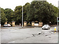
Alexandra Park
The northern entrance to Alexandra Park.
Image: © David Dixon
Taken: 13 Jul 2010
0.15 miles
9
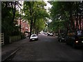
Range Road
Looking down Range Road, Whalley Range from its junction with Alexandra Road South. SJ83359537.
Image: © Keith Williamson
Taken: 28 Sep 2005
0.15 miles
10
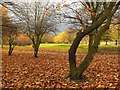
Alexandra Park in November
Taken facing the path parallel to Claremont Road, with one of the internal paths heading into the park visible as a grey strip mid-way down the image.
Image: © Marcus Hargis
Taken: 23 Nov 2006
0.15 miles