IMAGES TAKEN NEAR TO
Smalldale Avenue, MANCHESTER, M16 7JH
Introduction
This page details the photographs taken nearby to Smalldale Avenue, M16 7JH by members of the Geograph project.
The Geograph project started in 2005 with the aim of publishing, organising and preserving representative images for every square kilometre of Great Britain, Ireland and the Isle of Man.

There are currently over 7.5m images from over14,400 individuals and you can help contribute to the project by visiting https://www.geograph.org.uk
Image Map
Images are licensed for reuse under creativecommons.org/licenses/by-sa/2.0
Notes
- Clicking on the map will re-center to the selected point.
- The higher the marker number, the further away the image location is from the centre of the postcode.
Image Listing (60 Images Found)
Images are licensed for reuse under creativecommons.org/licenses/by-sa/2.0
Image
Details
Distance
1
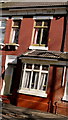
Terrace house on Smalldale Avenue in Moss Side
Terrace house on Smalldale Avenue in Moss Side, Manchester
Image: © Stephen Taylor
Taken: 14 Mar 2011
0.03 miles
2
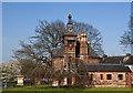
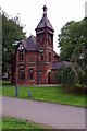
Chorlton Lodge
Built in 1868 Chorlton Lodge, one of the two original lodges in Alexandra Park, was recently carefully restored.
Image: © Ian Greig
Taken: 23 Apr 2015
0.03 miles
3
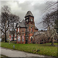
Lodge, Alexandra Park, Manchester
Alfred Darbyshire's vigorous lodge, complete with clock-tower, stands at the north-east corner of the park and dates from 1868 when the land was acquired by Manchester Corporation.
Image: © Stephen Richards
Taken: 17 Aug 2016
0.05 miles
4
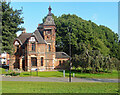
Chorlton Lodge, Alexandra Park
Alexandra Park is a 60-acre park located between Princess Road, Claremont Road, Demesne Road and Alexandra Road South, in the Moss Side/Whalley Range districts of Manchester. It was opened in 1870. The park contains Chorlton Lodge near to the Claremont Road Gate. The Lodge was designed by Alfred Derbyshire in 1868.
(http://www.manchester.gov.uk/info/200073/parks_and_open_spaces/188/alexandra_park/4 - Manchester City Council)
Image: © David Dixon
Taken: 7 Jan 2012
0.05 miles
5
Chorlton Lodge
The survivor of two Park Keepers lodges for Alexandria park built in the 1860's. It is now used for offices and community use.
Image: © Glyn Baker
Taken: 1 Sep 2018
0.05 miles
6
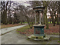
Alexandra Park, Drinking Water Fountain
Alexandra Park is a 60-acre park located between Princess Road, Claremont Road, Demesne Road and Alexandra Road South, in the Moss Side/Whalley Range districts of Manchester. It was opened in 1870.
(http://www.manchester.gov.uk/info/200073/parks_and_open_spaces/188/alexandra_park/4 - Manchester City Council)
Image: © David Dixon
Taken: 7 Jan 2012
0.07 miles
7
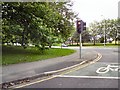
Claremount Road
The corner of Princess Street and Claremount Road
Image: © Gerald England
Taken: 21 Jul 2012
0.07 miles
8
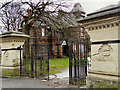
Alexandra Park, Claremont Road Gate and Chorlton Lodge
Alexandra Park is a 60-acre park located between Princess Road, Claremont Road, Demesne Road and Alexandra Road South, in the Moss Side/Whalley Range districts of Manchester. It was opened in 1870. The park contains Chorlton Lodge near to the Claremont Road Gate. Both the lodge and gateway are the work of Alfred Darbyshire.
(http://www.manchester.gov.uk/info/200073/parks_and_open_spaces/188/alexandra_park/4 - Manchester City Council)
Image: © David Dixon
Taken: 7 Jan 2012
0.07 miles
9
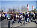
Moss Side Good Friday Walk Crossing Princess Road.
Princess Road is one of the main roads into Manchester. It leads from the city centre south towards the airport, M56 to North Wales, and the M6. Crossing at the Claremont Road lights is easy on the Good Friday walk with church members from nearby churches.
Image: © R Greenhalgh
Taken: 6 Apr 2007
0.08 miles
10
Alexandra Park in March (2)
This avenue of trees runs parallel to Claremont Road.
Image: © Marcus Hargis
Taken: 6 Mar 2005
0.08 miles