IMAGES TAKEN NEAR TO
Talbot Road, MANCHESTER, M16 0PW
Introduction
This page details the photographs taken nearby to Talbot Road, M16 0PW by members of the Geograph project.
The Geograph project started in 2005 with the aim of publishing, organising and preserving representative images for every square kilometre of Great Britain, Ireland and the Isle of Man.

There are currently over 7.5m images from over14,400 individuals and you can help contribute to the project by visiting https://www.geograph.org.uk
Image Map
Images are licensed for reuse under creativecommons.org/licenses/by-sa/2.0
Notes
- Clicking on the map will re-center to the selected point.
- The higher the marker number, the further away the image location is from the centre of the postcode.
Image Listing (92 Images Found)
Images are licensed for reuse under creativecommons.org/licenses/by-sa/2.0
Image
Details
Distance
1
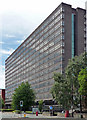
Oakland House, Talbot Road, Stretford
One of a cluster of substantial post-war office blocks in the Old Trafford area, perhaps part of a drive to attract business in the face of ailing industry. There is a local station, and the nearby A56 runs, in one direction, to what was the Stretford by-pass or M62 when it opened in 1960 (now the M60), and, in the other direction, to central Manchester.
This one is extraordinarily long, particularly in relation to its depth.
Its current occupants included several public bodies such as probation services and the local NHS trust.
Image: © Stephen Richards
Taken: 25 Jul 2011
0.09 miles
2
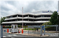
97 Talbot Road, Manchester
Quite striking with its extreme horizontality and far-oversailing roofs, rather in the tradition of Frank Lloyd Wright. It is symmetrical with a butterfly-shaped plan.
Currently occupied by British Gas.
Image: © Stephen Richards
Taken: 24 Jun 2011
0.09 miles
4
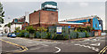
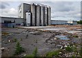
Factory, Elsinore Road, Manchester
Operated by CSM who, according to their website, "produce and distribute ... bakery products and ingredients for artisan and industrial bakeries". It looked a little run-down.
Image: © Stephen Richards
Taken: 24 Jun 2011
0.11 miles
5
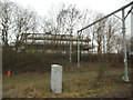
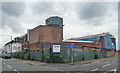
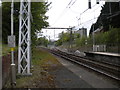
Former trackbed of the MSJ&A
Viewed from one of the Metrolink trams that now ply the route between Manchester and Altrincham, the catenary support frame here extends over a disused trackbed from when it was the Manchester South Junction and Altrincham Railway with a 4-track section. The western pair of tracks was removed in the 1960s.
The building in the background is the British Gas offices Image
Image: © Stephen Craven
Taken: 11 Mar 2017
0.11 miles
6
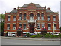
Trafford Hall Hotel Manchester 3-Star 23 Talbot Road, Old Trafford, Trafford M16 0PE
Used to be Trafford Public Hall
Image: © Robert Wade
Taken: 30 Aug 2009
0.12 miles
7
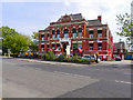
Trafford Hall Hotel
Trafford Hall Hotel, on Talbot Road. Formerly Trafford Public Hall.
Image: © David Dixon
Taken: 5 May 2011
0.12 miles
9
West end of Trafford Bar Metrolink stop
Looking towards Altrincham, with the connection from the line to East Didsbury and Manchester Airport rising to meet the main line visible ahead. The eastbound platform has been shortened to accommodate the junction, but the unused end of the westbound platform remains in situ. Trafford Bar is one of the railway stations adapted for use by light rail vehicles as part of the initial phase of Metrolink.
Image: © Richard Vince
Taken: 12 May 2018
0.13 miles
10
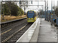
Metrolink, Trafford Bar
Metrolink Bombardier tram 3019 approaches Trafford Bar Station on its journey from Altricham to Manchester Piccadilly.
Image: © David Dixon
Taken: 15 Mar 2013
0.13 miles