IMAGES TAKEN NEAR TO
Skerton Road, MANCHESTER, M16 0NG
Introduction
This page details the photographs taken nearby to Skerton Road, M16 0NG by members of the Geograph project.
The Geograph project started in 2005 with the aim of publishing, organising and preserving representative images for every square kilometre of Great Britain, Ireland and the Isle of Man.

There are currently over 7.5m images from over14,400 individuals and you can help contribute to the project by visiting https://www.geograph.org.uk
Image Map
Images are licensed for reuse under creativecommons.org/licenses/by-sa/2.0
Notes
- Clicking on the map will re-center to the selected point.
- The higher the marker number, the further away the image location is from the centre of the postcode.
Image Listing (32 Images Found)
Images are licensed for reuse under creativecommons.org/licenses/by-sa/2.0
Image
Details
Distance
1
Firswood, community art
Metal globes along Addison Crescent; according to a notice, part of a community art project.
Image: © Mike Faherty
Taken: 17 Nov 2010
0.08 miles
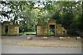
3
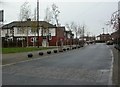
Addison Crescent Home Zone, Old Trafford
The Home Zone concept, called woonerf, was pioneered in the 1970s in the Netherlands, since then many countries have successfully transferred the core concepts and created their own safe areas. A home zone is a living street (or group of streets) as implemented in the United Kingdom, which are designed primarily to strike a balance between vehicular traffic and everyone else who uses the street, the pedestrians, cyclists, business people, children and other residents.
At present there is no specific legislation supporting Home Zones in the UK. However the government has given its support to nine pilot Home Zone schemes across England and Wales and the Scottish Parliament will be initiating 3 pilots in Scotland. In addition to the pilot schemes there are many other local areas which are setting up and working towards the Home Zone ideals.
The Addison Crescent Estate contains 256 households. The aims are to build safer communities, to improve the quality of life for children and young people, to enable sustainable economic and community regeneration and to tackle social exclusion through empowerment and community building.
http://www.homezones.org/homeUK.html Home Zones
http://www.lgcplus.com/government-announces-home-zone-challenge-winners-england/1309706.article Local Government Chronicle
Image: © David Dixon
Taken: 11 Feb 2015
0.09 miles
6
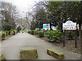
Seymour Park
The entrance to Seymour Park, from Seymour Grove.
Image: © David Dixon
Taken: 14 Mar 2012
0.12 miles
7
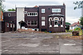
Throstle's Nest
The rear of the disused Throstle's Nest public house.
Image: © Peter McDermott
Taken: 19 Jul 2014
0.12 miles
8
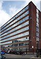
Trafford Plaza
A 1970s office block on Seymour Grove; recently refurbished.
Image: © David Dixon
Taken: 14 Mar 2012
0.13 miles
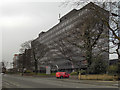
10
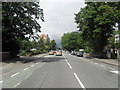
Grove House, Skerton Road, Stretford
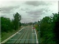
One of a cluster of substantial post-war office blocks in the Old Trafford area, perhaps part of a drive to attract business in the face of ailing industry. There is a local station, and the nearby A56 runs, in one direction, to what was the Stretford by-pass or M62 when it opened in 1960 (now the M60), and, in the other direction, to central Manchester.
Image: © Stephen Richards
Taken: 25 Jul 2011
0.14 miles