IMAGES TAKEN NEAR TO
Rosslyn Road, MANCHESTER, M16 0FY
Introduction
This page details the photographs taken nearby to Rosslyn Road, M16 0FY by members of the Geograph project.
The Geograph project started in 2005 with the aim of publishing, organising and preserving representative images for every square kilometre of Great Britain, Ireland and the Isle of Man.

There are currently over 7.5m images from over14,400 individuals and you can help contribute to the project by visiting https://www.geograph.org.uk
Image Map
Images are licensed for reuse under creativecommons.org/licenses/by-sa/2.0
Notes
- Clicking on the map will re-center to the selected point.
- The higher the marker number, the further away the image location is from the centre of the postcode.
Image Listing (17 Images Found)
Images are licensed for reuse under creativecommons.org/licenses/by-sa/2.0
Image
Details
Distance
1
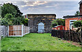
Thirlmere Aqueduct
Valve House on the Thirlmere Aqueduct.
Image: © Peter McDermott
Taken: 2 Aug 2021
0.06 miles
3
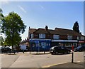
Tamzan Convenience Store
On Warwick Road South.
Image: © Gerald England
Taken: 4 May 2017
0.13 miles
4
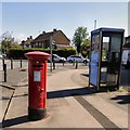
GR Postbox (M16 534)
On Warwick Road South.
Image: © Gerald England
Taken: 4 May 2017
0.13 miles
8
Firswood Tram Stop
Car No 3064 stopping on its way to Shaw.
Image: © Mike Faherty
Taken: 8 Feb 2019
0.18 miles
9
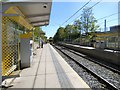
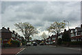
Firswood Metrolink Tram Stop
On the line to East Didsbury and Manchester Airport.
Image: © Gerald England
Taken: 4 May 2017
0.19 miles
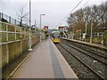
10
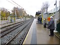
Firswood Metrolink Station
On the East Didsbury and Manchester Airport lines.
Image: © Mike Faherty
Taken: 28 Nov 2014
0.19 miles