IMAGES TAKEN NEAR TO
Albion Street, MANCHESTER, M1 5NZ
Introduction
This page details the photographs taken nearby to Albion Street, M1 5NZ by members of the Geograph project.
The Geograph project started in 2005 with the aim of publishing, organising and preserving representative images for every square kilometre of Great Britain, Ireland and the Isle of Man.

There are currently over 7.5m images from over14,400 individuals and you can help contribute to the project by visiting https://www.geograph.org.uk
Image Map
Images are licensed for reuse under creativecommons.org/licenses/by-sa/2.0
Notes
- Clicking on the map will re-center to the selected point.
- The higher the marker number, the further away the image location is from the centre of the postcode.
Image Listing (1485 Images Found)
Images are licensed for reuse under creativecommons.org/licenses/by-sa/2.0
Image
Details
Distance
1
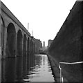
Lock No 90, Rochdale Canal, Manchester
This is the third lock from Castlefield Junction, where this canal joins the Bridgewater Canal. The surroundings here are typical of the Rochdale Canal's passage through central Manchester.
Image: © Dr Neil Clifton
Taken: 12 Apr 1981
0.01 miles

4
G-Mex station, Manchester Metrolink
Car 1005, one of the original trams modified for street running, departs on a service to Eccles.
Image: © Dr Neil Clifton
Taken: 10 Mar 2007
0.02 miles
5
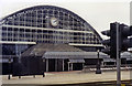
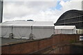
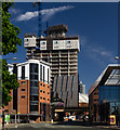
Former Central Station, Manchester 1992
Now the frontage of the GMEX Centre as seen from Windmill Street, until 5/5/69 this would have been a view towards the buffer-stops of the Cheshire Lines Committee (CLC) railway terminus, also (until 2/1/67) of the ex-Midland Railway services from London, Derby and Sheffield via Chinley. (See also Image).
Image: © Ben Brooksbank
Taken: 22 Jun 1992
0.02 miles
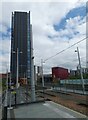
6
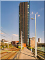
Axis Tower
Looking along the Deansgate/Castlefield tram stop towards the Axis Tower, a 28-storey residential building that dominates the skyline. Construction of the tower (Image]) began in 2017 and was completed in 2019. More information at https://en.wikipedia.org/wiki/AXIS_(Manchester) (Wikipedia).
Image: © David Dixon
Taken: 24 Apr 2021
0.02 miles
7
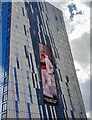
AXIS Manchester
A huge LCD video displays influencer Molly-Mae.
Image: © David Bremner
Taken: 11 Jun 2022
0.02 miles
8
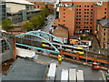
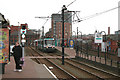
Metrolink, Great Bridgewater Street
The tram is descending from the Castlefield viaduct before beginning street level running on Lower Mosley Street outside Manchester Central.
Image: © David Dixon
Taken: 2 Jul 2012
0.02 miles
9
Axis Tower
The Axis Tower development.
Image: © Peter McDermott
Taken: 7 May 2018
0.02 miles
10
Axis Tower
Looking along the Deansgate/Castlefield tram stop towards the Axis Tower, a 28-storey residential building that dominates the skyline. Construction of the tower began in 2017 and was completed in 2019.
Image: © Gerald England
Taken: 1 Jun 2023
0.03 miles