IMAGES TAKEN NEAR TO
Bonsall Street, MANCHESTER, M15 6HJ
Introduction
This page details the photographs taken nearby to Bonsall Street, M15 6HJ by members of the Geograph project.
The Geograph project started in 2005 with the aim of publishing, organising and preserving representative images for every square kilometre of Great Britain, Ireland and the Isle of Man.

There are currently over 7.5m images from over14,400 individuals and you can help contribute to the project by visiting https://www.geograph.org.uk
Image Map
Images are licensed for reuse under creativecommons.org/licenses/by-sa/2.0
Notes
- Clicking on the map will re-center to the selected point.
- The higher the marker number, the further away the image location is from the centre of the postcode.
Image Listing (94 Images Found)
Images are licensed for reuse under creativecommons.org/licenses/by-sa/2.0
Image
Details
Distance
1
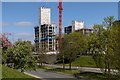
Hulme
MMU Birley Fields Campus Phase 2 development site at Hulme.
Image: © Peter McDermott
Taken: 13 Apr 2020
0.01 miles
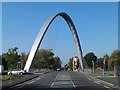
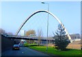
6
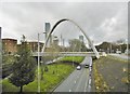
Hulme Arch Bridge
Hulme Arch Bridge carrying Stretford Road across Princess Road in Hulme, Manchester.
Image: © Peter McDermott
Taken: 15 Feb 2015
0.04 miles
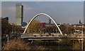
7

Hulme Arch Bridge
Looking along Stretford Road to the Hulme Arch Bridge. See also Image
Image: © Peter McDermott
Taken: 22 Nov 2015
0.04 miles
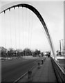
8
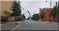
Towards the Hulme Arch Bridge
A view down Cavendish Street towards the Hulme Arch Bridge in the Hulme area of Manchester.
Image: © Steven Haslington
Taken: 17 Jul 2016
0.04 miles
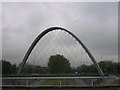
9
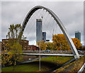
Hulme Arch Bridge
Image: © Peter McDermott
Taken: 4 Nov 2018
0.04 miles
10
Hulme Bridge
Carrying Bonsall Street over Princess Road.
Image: © Mike Faherty
Taken: 7 Feb 2019
0.04 miles